
The Los Angeles City Historical Society was recently gifted a nifty collection of vintage images, which they Tuesday last, posted online:

And when that sort of thing happens, if there’s Bunker Hill involved, I’ll comment upon it, naturally (e.g. when this trove popped up on Google Arts and Culture).
Let’s get into into it. Part I: The Bunker Hill Stuff
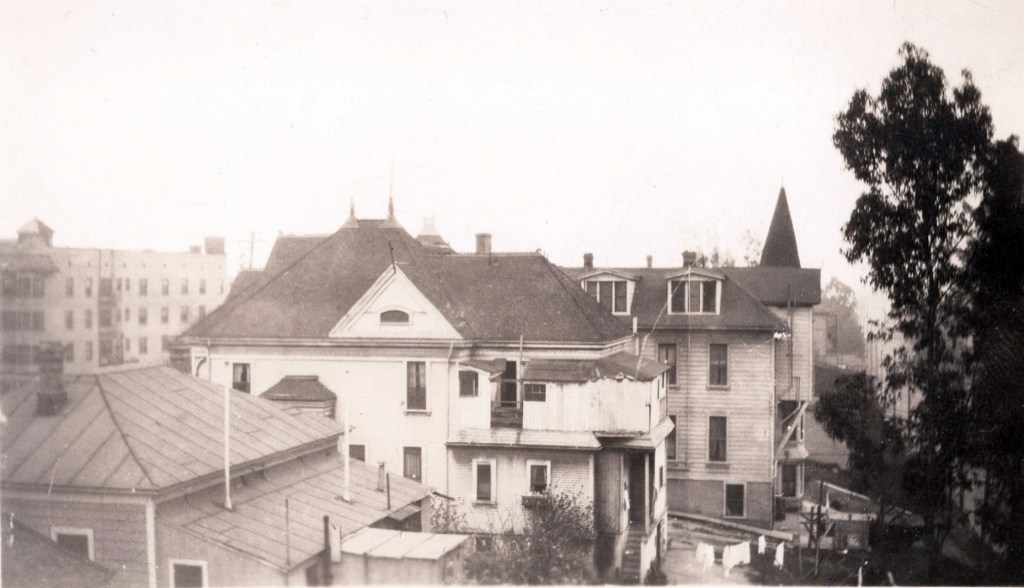
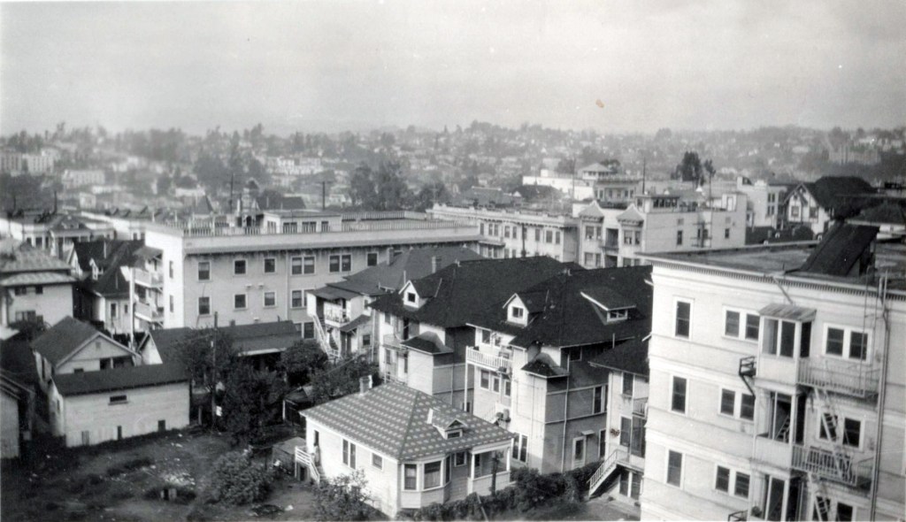
Above, we look south from atop the Rowan Apts, which fronted on 123 South Bunker Hill Avenue (and 116 South Hope Street below). Our photographer peers across the rooftops: bottom left we see a wee bit of the roof-corner of 125 SBHA, then 133 SBHA, and 137 SBHA (with laundry hanging to dry in the backyard) and most prominent, with its witch-hat tower sticking up, is the north facade of 145 South Bunker Hill Avenue, best known as the Berke Mansion. At far left, one can see the unadorned west facade of the Dome at Second and Grand, and a bit of its bay-windowed north facade. Just a really, really unusual view.
Now, WHY would such an unusual and particular shot be taken? Because it was captured by one Mr. James Daniel Horgan, a wholesale grocer, who lived at the Rowan.
Horgan came to Los Angeles from Wisconsin in 1904, and in the early 1920s lived at 1717 South Maple. Horgan moved onto Bunker Hill in 1923, living at 335 South Olive, where he stayed until 1927. He then moved into the Rowan, and remained through the 1930, ’40, and 1950 census. When he died in 1954, though, he was living at 3964 East Blvd, Culver City.


Shots of The Rowan, Horgan’s home, are few and far between, but there is one in Bunker Noir!—

Now granted, that shot was unusual. Some of the shots of Bunker Hill are “usual suspects,” e.g. the Castle and the Melrose, arguably the most photographed of the Hill structures:

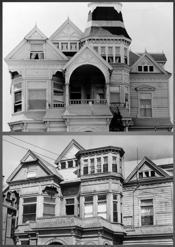
This is the Castle, 325 South Bunker Hill Avenue. This was shot post-1937, because the earthquake-damaged balcony and tower were removed when Margaret Pattison purchased the property in ‘37. A before-and-after showing tower and balcony:
And now the Melrose—

This is about 1932, when the Melrose still had its original cupola tops intact. They were removed after the ’33 quake, in tandem with a 1934 reroofing.

The Melrose Annex (Thomas J. McCarthy, 1902) at left, and at right, the Richelieu. Note at far right the Moderne apartment building, which postdates these Horgan images to 1939.
Further north:

This is a pretty nifty shot, where Horgan stands at the north end of the Hill Street Tunnel and peers up to the Fort Moore area. The large structure at center-distance is the high school (Jasper Newton Preston, 1890), demolished 1936.

Horgan’s photo dates to about 1934. For a similar shot captured in 1919, turn to page 47 of Bunker Hill, Los Angeles:
Then there’s this vexatious fellow:
I get the feeling that we’re situated somewhere in the criminally underphotographed Temple/Beaudry area, perhaps around Bixel at Court. Is that dark shape upper-right-distance the Sisters Hospital up on Sunset? This will take more study, but for the moment, we press on.
PART II — NOT BUNKER HILL
Not Bunker Hill, but pretty nifty nonetheless, with a lot from the adjacent Civic Center area.
One of my favorite structures in the whole of Los Angeles architectural history:

LAPD Central, at 318-24 West First St., built in 1896, designed by Charles Lincoln Strange as a Romanesque Revival fortress. Its facade was damaged in the Long Beach Quake, and so its front was rebuilt and modernized in the spring of 1934…but only the top two stories, which made for a curious amalgam indeed. The “architect” for the facade remodel was the City’s Bureau of Construction. Never thought I’d see this work under construction. This building is so important (and Bunker Hill Adjacent) it merited inclusion in Bunker Noir!—

Central was demolished in 1956, and State Office Building #2 (Stanton & Stockwell/Anson C. Boyd, 1960) would be built on the site; the force had moved three blocks east over to the new Police Facilities Building.
We head a bit further east:
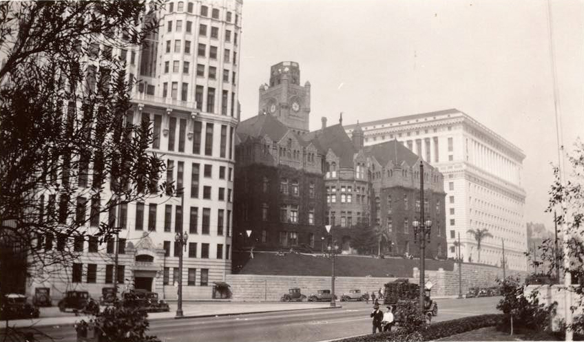
The old red sandstone Courthouse (Curlett, Eisen & Cuthberton, 1891) was already having issues before the quake.

Despite the tower being lowered significantly, after the ’33 quake, the whole works were condemned, and demolished in the spring of 1936:

Next door is the Hall of Records (Hudson & Munsell, 1911), which persevered all the way until 1973.

Here’s the Times building—we’re looking at the NE corner of First & Broadway:

The first Times on this site (Caukin & Haas, 1887) was, of course, famously blown up by organized labor, killing 21 workingmen, and destroying the building. This replacement (Kremple & Erkes, 1912) was made superfluous and dispensable with the construction of the new Times building across the street. Ergo, it became the site of the new State Building. Strangely, because of issues removing the 1912 Times building (it was commandeered by the City for CIvic Center improvement, but the City and the Times could not come to agreement on compensation for years, and then the City and County argued over title), it co-existed with the new State Building for years, before finally being demolished in early 1938.

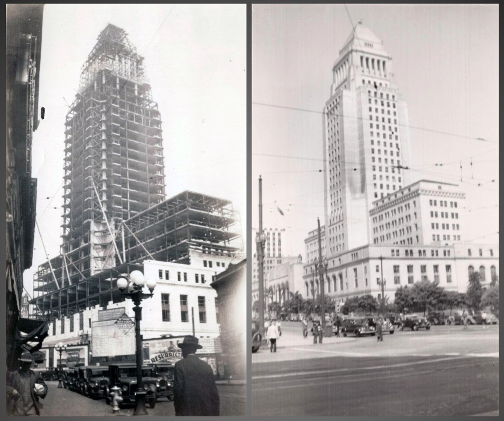
The mighty State Building (A. C. Martin, 1931) was felled in 1975. Once you could go stand on the wonderful marble flooring of its lobby, recently torn up and in some landfill.
Speaking of the new Times Building—

Of course I don’t have to introduce this fellow…
…but if you’ve any questions on the matter, I suggest you read the book.
Now we’re getting a little further afield—

This is looking up Weller Street. The Salvation Army at left was 129 Weller; the structure at the end of the block is the corner of First and Los Angeles.
Here we are atop the roof of the hotel at the northeast corner of Second and San Pedro:
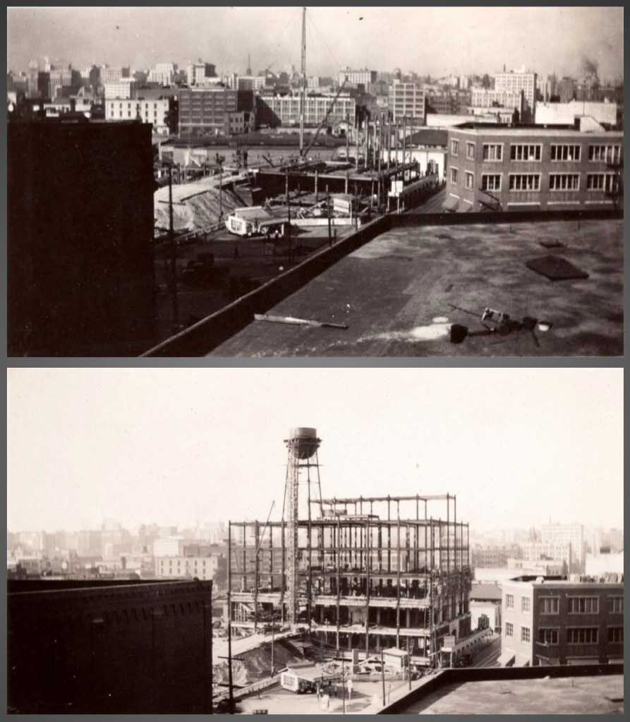
We look west on Second to Brunswig Drug’s excavation site at 360 East Second Street, late 1930, skeleton up in early-mid 1931.
Brunswig Drug lost four buildings to the 1930 widening of Spring Street. Thus they moved operations from their historic 501 North Main Street location to here. This Art Deco wonder—a quintessential American interbellum daylight factory—was designed by the firm of Albert C. Martin.


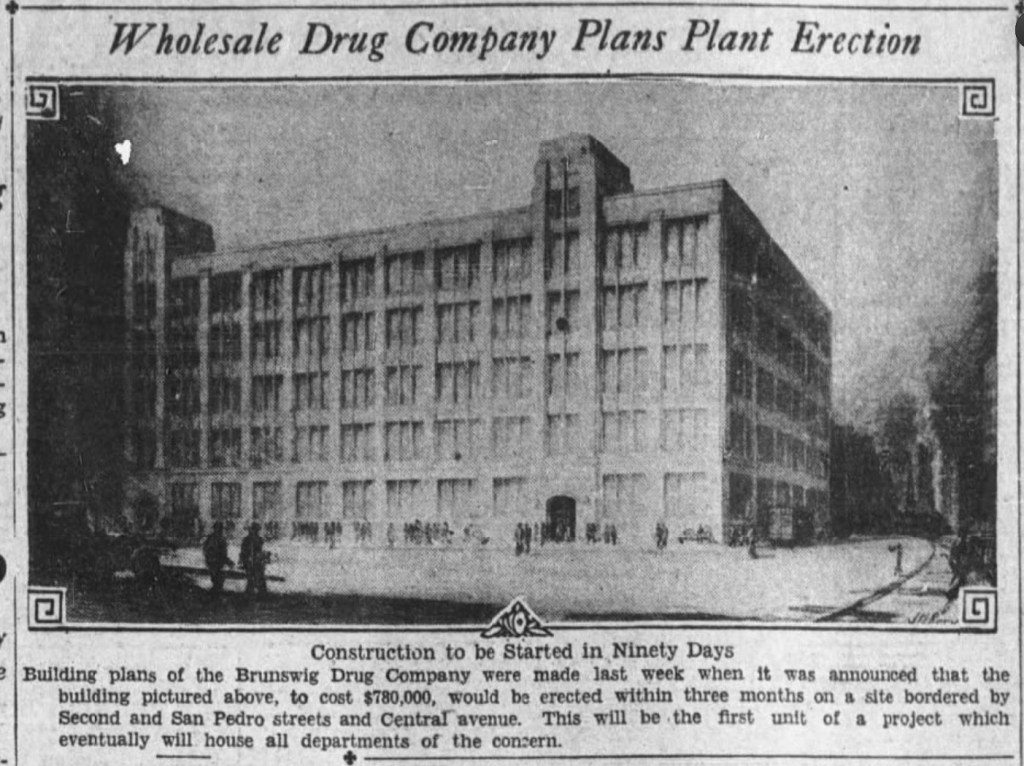
This structure is still there, sort of; it had three stories added and was reskinned by Reeves Associated Architects in 1985-86.
Here, we look south down Second; the intersection is Rose:

At bottom left we’re looking northeast: the soap company, far left, is at First and Hewitt, the gasometers behind at Jackson and Center.
A couple shots of County Hospital’s construction and completion:

Lastly, some things much further afield—
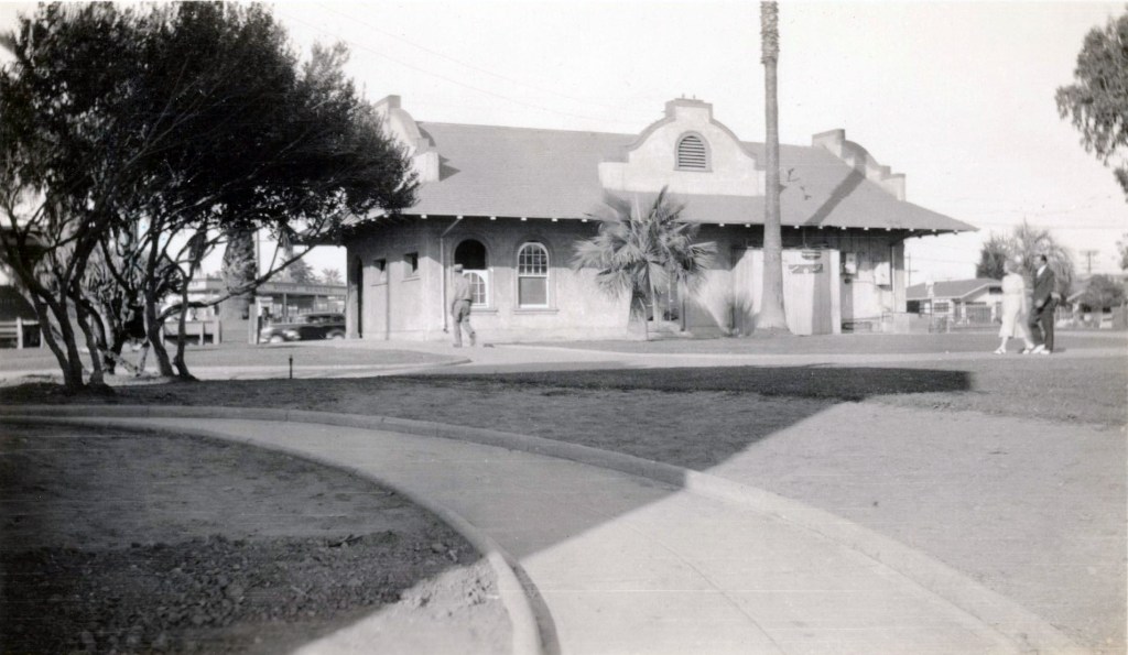
This is the Pacific Electric depot, 1450 Ocean Avenue, Santa Monica.
And this is Point Fermin lighthouse:

And lastly—
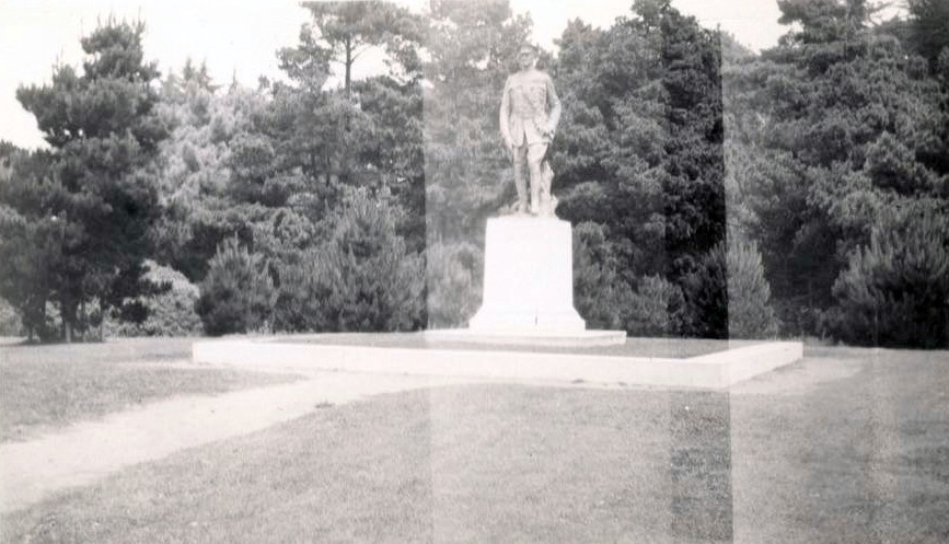
Why, it’s the statue of Gen. John J. Pershing, all the way up in San Francisco’s Golden Gate Park. A couple links to Los Angeles: San Francisco’s Pershing is by Haig Patigian, who produced the major sculpture for our lost, lamented Richfield Building. And, of course, we have Pershing Square! (Or we do for the time being, unless bands of misguided and ill-informed philistines succeed in renaming it.)
And so goes my identification of—some of—those images posted by the Los Angeles CIty HIstorical Society. Their post contained sixty total, so there are plenty more for you to look at, including a handful that stumped me totally…your job is to identify those not featured here, and email me so I might update this post. Thanks in advance, you crazy kids you!

Altogether a stash worth it’s value to we antiquarians—-eh?
LikeLike
Wow Nathan!Thanks for another captivating post.I love the photos only because of the context your comments bring to them. Check out this assemblage I made 25 or 30 years ago. Title: “Hall of Records”.I am old enough (cough, cough!) to remember the old Hall of Records. I was very sad when the old lady came down.I have been fascinated with the old Bunker Hill for 45 years. An environment I never experienced firsthand, but hold a deep nostalgia for.Leslie
LikeLike
Once again, astonishing, thoroughly researched tour de force. Much appreciated. Thanks again, Nathan.
LikeLiked by 2 people