Our story so far: we introduced our subject in Part I by detailing how Chavez Ravine’s popular mainstream narrative is aggressively counterfactual. Part II answered the question of “what is this Chavez Ravine?” Part III gave a rough sketch of what life was like in Palo Verde, La Loma and Bishop during the postwar era, before it was depopulated. Part IV ran us through the history of the Elysian Park Heights project, under whose aegis the area was cleared.
Today! You’ve probably heard of the Dodgers. And you know their stadium is in Chavez Ravine. How did they get there? Let’s find out!
Vice President, Director of Stadium OperationsDick Walsh, President Walter O’Malley, and General Manager E.J. “Buzzie” Bavasi. August 26, 1960. LAPL
I. A Team Called the Dodgers
In the previous installment we dealt with Chavez Ravine as it related to postwar public housing projects and the subsequent demolition of homes in the Ravine, etc.
During that time, out in Brooklyn, there was a baseball team called the Dodgers. They played at an aging (built 1913), small stadium, with little parking, called Ebbets Field. The team and stadium were owned by a fellow named Walter O’Malley.
O’Malley was in the works to build a new, capacious, privately-owned domed baseball stadium on Flatbush Avenue in Brooklyn, but was thwarted by government. New York City Building Commissioner Robert Moses insisted it be a city-owned stadium, and had to be located in Queens. O’Malley and Moses battled over this for years on end, both certain they’d get what they want.
In late 1956 O’Malley was in Los Angeles, and even gave a speech about how and why he would not move the Dodgers to Los Angeles.
O’Malley had been working for ten years to replace Ebbets Field, stymied by Moses, and was hoping against hope he’d still be able to build his dream stadium in Brooklyn. But by the spring of 1957 he’d had enough of New York’s corruption, so he looked to sunnier climes.
In May 1957 we finally got O’Malley out to Los Angeles, to look at a half-dozen prospective sites. O’Malley goes up in the whirlybird—May 2, 1957—and from the air examines Wrigley Field (which O’Malley had acquired the previous February) and the Coliseum, etc. But then O’Malley saw the stacks, AKA the famous four-way freeway interchange, right next to a huge piece of empty land.
He had seen Chavez Ravine, and concluded if he was going to spend twenty million dollars out of his own pocket to build Los Angeles a stadium, that’s where it was going to be located.
The city had zero money for any of its lofty and various Ravine plans (lake/college/zoo/expansion of the Police Academy, etc., much less a massive ballpark). The idea that someone else would spend the millions to build a 50,000-seat stadium was a godsend.
There exists a persistent mythological narrative that the City had always planned to displace the people of Chavez Ravine for a stadium. Not only is that not true, as borne out by the simple chronology of events, but there is a paper trail to prove that contention false. A July 1956 Los Angeles Department of Recreation and Parks study, investigating the idea of a stadium in a dozen some-odd places around Los Angeles, noted this about Chavez Ravine, when it dismissed the idea: “The rugged topography of this area does not appear to be desirable for the proposed use,” adding “most of the property considered for this use is owned by the City of Los Angeles and is vacant. Abutting land is in private ownership and, except for a few small residences, is vacant.” So not only did they note the area to be vacant (when revisionists say it wasn’t) the Powers That Be still didn’t consider it useful stadium territory.
II. Regarding Public Purpose
The City had long since repurchased their land from the Feds, so it belonged to the City to do with as they pleased. There existed the stipulation—as written into the Housing Authority deed transfer—that the land be used for a public purpose. A lot of people will yell at you that “a baseball stadium is not a public purpose!”
Um, when there’s 56,000 people there, I fail to think of a better definition of public purpose. I’m not a sports guy and personally don’t care about baseball—but I do acknowledge there’s enormous public purpose value to the vast civic pride the Dodgers bring. Above and beyond the Dodgers, I remember when 56,000 people were crammed therein to see John Paul II perform mass. People also filled it to see The Beatles and Bowie and the Stones and Springsteen and Guns n Roses and Michael Jackson, and on and on (even Elvis, sort of, who filmed Spinout in the stadium parking lot) … speaking of race cars and public purpose, did you know there used to be awesome road races in the parking lot?
Anyway, I say that fits the definition of public purpose, though some certainly insist it does not, but…
… you want to know the kicker? The whole “public purpose” clause of the Housing Authority deed restriction was made void by the Court in a unanimous decision anyway, so there’s literally no reason for people to talk about it … but they sure do anyway. In short: the CHA transferred the land to the City with the “public purpose” clause, that did not in any way define what “public purpose” actually meant or entailed. Arguments over the public purpose deed restriction were made in trial courtrooms through the summer of 1958 in Los Angeles Superior Court. The matter went to the State Supreme Court, where it was decided the the public purpose restriction had in fact been fulfilled.
But oh! they continue, that may be true buuuuut….public purpose doesn’t have to be legal, it’s moral, and all that civic pride is only just making money for the owner, it’s therefore immoral and not a public purpose! Well if we’re going to talk about money: Chavez Ravine, before its condemnation by the government, containing all those La Loma/Palo Verde/Bishop residents, paid a yearly sum total of $7,400 in property taxes. In the first year after having opened the stadium, the Dodgers paid $345,000, a 50-fold increase of money into the City coffers. Over the last sixty years the Dodgers have paid nearly a billion dollars into the City coffers just from property taxes. Not to mention the state and local taxes, employment opportunities, entertainment spending, and so forth. When the City spends money on roads, schools, wastewater treatment, public safety, and all that jazz, a billion dollars of that money came to the city via a private entity building a stadium on their own dime.
Again, the California Supreme Court ruled in favor of public purpose in January 1959 (City of Los Angeles v. Superior Court) when it said that the contract with the Dodgers brought such enormous benefit to the City, and had thus fulfilled and nullified the deed restriction. After which, the California Supreme Court unanimously sustained its ruling repeatedly through 1959.
But oh! you will be instructed, the city should have built its own stadium, then it would be *ours*, and not in the private hands of dumb private people! Sorry, but as I just mentioned, in the late 1950s the City of LA did not remotely have that kind of money to build a stadium, and if we had, the City would never have received that $1billion in property taxes.
But because I hear a lot about how the City lost out because it did not build its own municipally-owned and run stadium, let’s devote a few paragraphs to the difference between the privately-funded, and the taxpayer-funded, American ballpark:
Now remember, a privately-funded ballpark is as rare as hen’s teeth…for a reason. Yes, Walter O’Malley got two 99-year leases for $1 a year—cue the chorus of it’s a backroom deal conspiracy and he stole the land!—but the fact stands, he spent $23million out of his own pocket to build the stadium (oh, and before you say he was “given” the land, nope, he deeded land he owned, worth about $2million, to the City of Los Angeles, in exchange for Chavez land, worth about $2million). Then O’Malley spent his $23million to build the stadium, which, adjusted for inflation he therefore spent, in today’s money, $242million. That’s a quarter of a billion dollars out of O’Malley’s pocket to build the stadium, which, 62 years later, remains an exceptional stadium.
Conversely, from the 1920s to the 60s, all the major American ballparks were constructed as municipal stadiums, built by local governments, paid for by taxpayers. The last privately funded baseball stadium had been Yankee Stadium, and that was in 1923. So when people say the City of Los Angeles could have/should have built the stadium itself instead of having someone else do it, remember again, we didn’t have the money, and more importantly: municipally-constructed stadiums are crap.
You read that right, total crapola. After all, look at taxpayer-built Candlestick Park or Shea Stadium. Oh wait you can’t, they’re both demolished. Milwaukee stadium, built with public funds in 1953, torn down. Kansas City, built with public funds in 1955, demolished. It’s an amazing fact to consider, but a dozen-plus major league baseball stadiums have been built and torn down just during the time since Dodger Stadium opened in 1962.
Municipal stadiums, being government owned and run, suffer (or, more likely, suffered) one and all from bad design, poor maintenance, and cost overruns.
Dodger Stadium, though, being privately built and owned, remains as a monumentally important piece of architecture, and an actual, functional stadium. Because O’Malley said “I want the largest and most modern stadium in the world,” that’s what he paid for, designed by Emil Praeger of Praeger-Kavanagh-Waterbury. It’s the third oldest baseball stadium in the US, after Wrigley and Fenway (which both predate WWI).
And irrespective of it housing the Dodgers, it’s an amazing piece of Mid-Century Modern, with those folded plate roofs and inverted canopies and martini glass planters; it embodies all the futuristic optimism that defines postwar Southern California.
This image is among many will see when you read Steve Keylon’s incredible essay about Dodger stadium landscaping, here.
Here in Los Angeles the last time we built a stadium was in Inglewood. It opened a couple years ago, after a guy named Stan Kroenke spent three billion of his own dollars on the thing. Now he’s on the hook to make sure his investment pays off. If it were run by local government, well, you know how that would go.
III. Illegal Backdoor Deals!
The stadium and the team is there in Chavez Ravine, and you will be told “it’s because of illegal backdoor deals!”
Um, no. Not only was the whole enterprise under intense public scrutiny, and approved by the City Council after lengthy debate, and approved by the courts (up to and including the California Supreme Court), it actually went to the voters. The terms of the much-debated October 1957 contract were pretty simple: O’Malley would deed a piece of land to the City (Wrigley Field) valued by city appraisers at $2.2 million, and in an even swap, the City would deed Chavez land to O’Malley, valued at city appraisers at $2.2 million. Then, O’Malley would build a 50,000-seat stadium out of his own pocket.
This was put before the City Council, who approved it.
It was then handed to the People of Los Angeles who, like the City Council, could have tanked the whole thing and put Chavez Ravine back to square one:
Not only was the Dodger contract approved by the voters, but the Ninth District—which covered the Chavez Ravine area and was represented by Councilman Ed Roybal—had one of the largest margins of approval for the referendum.
So, never having been engaged in an “illegal backroom deal” maybe I don’t know what one is, but I can absolutely tell you what it’s not: something endlessly hashed out in the press and by the courts, and thereafter being approved by City Council, and then being approved by the majority of the voters. The Council or the people of Los Angeles could have easily nailed the Dodger coffin lid shut and sent them packing, if franchise relocation and stadium-building had in fact been the violent and criminal thing we are constantly led to believe. Dodger relocation, the Chavez Ravine deal, and so forth: exactly the polar opposite of anything illegal or “backdoor.”
One more thing. In June 1958, after the voters approved Dodger Stadium, Judge Arnold Praeger said “I don’t care what the City Council and people of Los Angeles say, I rule the City’s contract with the Dodgers as invalid!” At which point the California State Supreme Court voted unanimously (7-0) to reverse Praeger’s decision, and Chief Justice Phil B. Gibson embraced the Supreme Court ruling, to uphold the contract between the City of Los Angeles and the Dodgers, for which the citizens of Los Angeles had voted. Again, literally the opposite of a backdoor deal.
Anyway. Groundbreaking for the stadium is September 1959, and it opens in April 1962, and that is that. Hey, I don’t know from baseball, but there are few things I love more than a Japanese garden.
And…there it is. I don’t go to baseball games myself, but I did like Dodger Stadium’s inclusion in Hickey & Boggs at 1:10.
Before groundbreaking, however, the final holdouts had to be removed. That story, coming up next in Part VI: The Arechiga Family!
**********
This is seven-part series. Its component parts being:
A snapshot of life in the area in the 1940s. The mythos of small-town life; Normark’s documentary work; a study of the people of Chavez Ravine; churches, markets, bus lines, etc. Published Tuesday, May 14.
A history of public housing; Neutra’s Elysian Park Heights project; its proponents and opponents; the area’s demolition; the downfall of public housing, and its relationship to anticommunism; land use after the demolition and nullification of the contract. Published Thursday, May 16.
Part V: Here Come the Dodgers
About the Dodgers; what constitutes public purpose; an illegal backroom deal? Published today, Monday, May 20.
Part VI: The Arechiga Family
The Arechiga family history to 1950; eviction from Malvina Street; eventual removal in May 1959; the multiple Arechiga houses; life after Malvina; the next generation of Arechigas. To be published Thursday, May 23.
Part VII: In Summation, plus Odds and Ends
Key takeaways; plus a collection of *other* commonly-held beliefs about Chavez Ravine, conclusively debunked. To be published Sunday, May 26.
If you have comments or corrections, please don’t hesitate to write me at oldbunkerhill@gmail.com.
The story so far: In Part I, we outlined how the habitual narrative—including most everything that made it into the Reparations Bill—is a mixture of urban legend, conspiracy theory, manipulated facts, confirmation bias, and outright nonsense. In Part II, we examined the area’s genesis and growth into the 1940s. In Part III, we looked at a snapshot of life in the Ravine in the 1940s, immediately before the turn of events that would erase the neighborhoods and reshape Chavez Ravine forever.
And why was Chavez Ravine depopulated and demolished? Because the City knew best! Read all about it:
************
It’s a sunny summer day in 1950. You live in Chavez Ravine. Minding your own business. You enjoy the open spaces, the fresh air. You love the yards full of ripe vegetables, the streets full of happy children, the hills full of grazing sheep. You get home from work one day—
The suit is very officious. He’s got a fellow in tow who translates into Spanish for him. That guy seems nicer, but what he’s saying is terrifying: “We’re here from the government, and we’re here to help you.” There are no more chilling words in any language.
Then they pull out this letter, hand it to you, and move along to the next house.
Good news, it says, we’re taking your home.
The Mexican fellow is named Ignacio “Nacho” Lopez. He’s a Spanish-language newspaper publisher and civic activist.
The suit is named Frank Wilkinson. He’s an ardent leftist, and as such, he and his buddies know what’s good for you.
That’s a statement that may bristle some readers, but it is absolutely accurate. The common narrative is frequently “greedy Republican developers kicked out the residents of Chavez Ravine” but that could not be further from the truth.
Don’t believe me? Read on!
I. A Short History of Public Housing
It’s 1929, there’s a stock market crash, and faith in laissez-faire capitalism is shaken. Therein begins our nation’s shift into Keynesian economics, whereby large-scale macroeconomic state intervention is considered necessary, and therefrom we enact a welfare state and other programs protecting the working class against the ravages of capitalism.
The Roosevelt Coalition steered us into a world of mass social engineering. From this came the fifty-some alphabet agencies, like the NRA and the WPA. Mass American slum clearance began in 1933 under the PWA, the Public Works Administration, and ramped up in 1934 via the FHA, the Federal Housing Administration.
Progressive Democrats believed that remaking the physical environment would improve living conditions and engender better social behavior, so, we take your home—despite it having fresh air and chickens—and put you in the projects, AKA huge reinforced concrete filing cabinets for humans. The courts said no, that’s literallyun-American and you can’t do that, so Roosevelt said ha ha! here’s my Housing Act of 1937, which gave the State absolute power on the matter.
And with that came the USHA, the United States Housing Authority, whose first Director was Catherine Bauer. Bauer was trained in Europe and under the sway of Le Corbusier, from whom blossomed large scale concrete mass housing. Bauer literally traveled to Russia to see how they were doing it, came back and said, well, if its good enough for the Soviets it will be good for America!
Meanwhile Los Angeles Mayor Frank Shaw, a staunch supporter of the New Deal, through LA’s Municipal Housing Commission, got assistance from the PWA to clear slums in 1934. He then established Los Angeles’s Housing Authority in March 1938 and contacted Bauer and said hey Ms. Bauer, be a pal and give us $25,000,000 for slum clearance. Bauer wrote Shaw the check, at which point Los Angeles starts taking people’s homes and businesses and began building housing projects.
The Southwest Wave, July 5, 1938
Lincoln Heights Bulletin-News, July 7, 1938
Before the start of World War II—before we really started cooking building housing projects—we’d cleared 175 acres and built about 3,500 units.
You will be told that there was something illegal (or at least special) about the removal of all the residents of Chavez Ravine for public housing, but, we literally did it all the time. Between 1937 and 1942 thousands were removed for the construction of Ramona Gardens, Pico Gardens, Pueblo Del Rio, Rancho San Pedro, Aliso Village, William Mead, Estrada Courts, Rose Hill Courts, Avalon Gardens, Hacienda Village…and were those all illegal evictions? You might say confiscating people’s homes is morally repugnant—you might be right—but it was typical and standard fare. Hard to argue something’s illegal when it’s cleared by the courts time and time again.
The aforementioned ten prewar housing projects were built via Roosevelt’s New Deal program. His successor, another Democrat named Harry Truman, had the less-remembered “Fair Deal.” Truman’s Fair Deal had a housing act in 1949, with greater powers than his predecessor’s 1937 legislation: just under the 1949 Housing Act, Los Angeles cleared 276 acres of slums and built 4,350 units, at Jordan Downs, Nickerson Gardens, Aliso Apartments, Pueblo del Rio extension, Rancho San Pedro extension, Imperial Courts, Estrada Courts, Mar Vista Gardens, and San Fernando Gardens.
Here’s where you’ll accuse me of whataboutism, but, what about the two and a half thousand people forcibly removed by the Housing Authority from the area between First and Temple Streets, in 1949-50, for the expansion of the Civic Center? Or the 9,000 people removed for the Bunker Hill project? How are the people of Chavez Ravine special, and above and beyond every person whose home was taken and demolished for a school, police facility, fire station, civic/government building, or freeway? Point being, the idea of demolishing Chavez Ravine was neither new nor unusual, especially after the 1949 Housing Act (which demolished 400,000 structures nationwide).
It is often asserted that the people of Chavez Ravine are noteworthy or remarkable because in their case the government project wasn’t eventually built (neither was the vast early-1950s expansion of Rose Hills, cancelled along with Chavez Ravine, which took people’s homes and that didn’t get built either; no-one ever mentions other government projects that took homes and remained unbuilt, like the 710 Freeway extension). Fact is, the Chavez Ravine homes were bought, paid for, and demolished, before the project was cancelled; the people to whom the lands might be returned had moved on. More to the point, the concept of Chavez Ravine Exceptionalism was argued in the courts repeatedly, and the government was affirmed as owner each time, irrespective of the project being cancelled.
Los Angeles Times, 09 May 1959
Back to 1950: Chavez Ravine denizens get the letter that says we have to kick you our and remake the landscape in toto. The Housing Authority chose that land because when the health department did a survey, one third of the houses had no toilets, and a quarter had no running water.
While a third were made from standard building materials, the other two-thirds were in poor condition or constructed of packing cases, or old lumber of insufficient grade to legally build with, and the like. The area’s tuberculosis rate was four times that of the city. A typical sampling of news notices regarding the area:
Los Angeles Mirror, 30 November 1948
Los Angeles Evening Citizen-News, 05 June 1948
Los Angeles Times, 05 February 1949
Los Angeles Daily News, 08 August 1950
Los Angeles Daily News, 09 August 1950
In short, Chavez Ravine was boilerplate slum clearance and project building, just like the two dozen other federally-subsidized projects Los Angeles had built.
II. Elysian Park Heights
In Los Angeles, slum clearance/building public housing projects was a common and routine activity, but: our particular Chavez Ravine project was to be quite different from the others we’d built. A lot different.
What made the Chavez Ravine project—named “Elyisan Park Heights”—so dissimilar, was the scale and scope of what was going to replace the semirural sunny slopes. The Elysian Park project was massive, intended to put us in the league with the “big boy” cities constructing huge high-rise housing projects.
LA’s public housing had been, up to then, low-rise, two-story, comprised of open spaces with courtyard living. Here’s a handful of examples, to give you an idea of the traditional massing of Los Angeles public housing:
For Chavez Ravine, the Housing Authority of the City of Los Angeles, with the Federal Housing Authority, bought up 806 individual Ravine parcels, in an effort to build this:
Their plan was to chop down the hills, fill in the ravines, pave the thing in concrete, ring it with 24 thirteen-story concrete apartment blocks, and fill in the middle with another thousand units, in 163 two-story buildings.
Los Angeles Times, April 11, 1951
Yep, large housing towers, just like the big projects in eastern cities, which by and large did not go well. Many large-scale postwar projects have had to be demolished because they became ungovernable and dangerous. Los Angeles’ Elysian Park Heights: built on the same model as Chicago’s Cabrini Green—which fared so poorly, and we had to tear it down. Los Angeles’ Elysian Park Heights: built on the same model as St. Louis’ Pruit-Igo—which became so unmanageable, we had to blow it up.
At 3364 units, Elysian Park Heights would have been larger than Queensbridge in New York; Queensbridge is America’s largest, and arguably the most dangerous, housing project.
Let me be clear, I’ve nothing against public housing. It fulfills a necessary purpose and by and large, it is well-run and provides decent and affordable housing for people in need. But there is, statistically, a major difference between low-rise and high-rise public housing. Studies show that crime increases proportionally with height. Only 27% of government housing in America is highrise, and yet that 27% provides the vast majority of the problems, from drug dealing and murder, to unemployment and single parenthood. In every instance, highrise public housing has led to greater segregation by race and of the poor, impacted by underfunding and government neglect, which only perpetuated the cycle of both physical and societal decay.
People say “but Neutra was such a great architect! OURS would have been amazing!” Here’s Neutra designing the thing with all his Viennese best intentions.
Neutra, seated, with Robert Alexander, hard at work designing Chavez Ravine’s future, October 02, 1950. Getty/Nadel
Of course you can’t prove a negative, so there’s no telling what Elysian Park Heights actually would have turned out like. That said, yeah, nah, I *am* gonna tell you what Elysian Park Heights would have turned out like, Neutra be damned: an isolated urban high-rise reservation. With the poor shunted off into concrete height-limit filing cabinets, the whole thing would have incontrovertibly descended into a dystopian nightmare of bizarre proportion. That’s just my opinion, but I sure have a lot of precedent to back up my argument.
Point being: EPH was to be obnoxiously huge like those projects back east, which are famously plagued by dead elevators, broken windows, drugs, crime, and malaise. Now consider, in Los Angeles we’ve had to tear down plenty of our little ones. We’re tearing down Jordan Downs and tearing down Rose Hill Courts. EPH would have just been a high rise version of Aliso Village, which we had to tear down because it was more dangerous than Fallujah. Miraculously, concentration and isolation in high-rise inner-city ghettoes was something Los Angeles had somehow managed to avoid. Oh, but don’t worry, Neutra will figure out how to give us a 3500-unit project that will magically prevent pesky modern problems like crime and despair. (Just so we’re clear, I’ve nothing against Neutra, a brilliant Modernist who produced many of the most compelling icons of the age, but his talent lay in designing homes and offices for his deep-pocketed celebrity clients.)
III. Who Wanted Elysian Park Heights?
I told you about Wilkinson, the Red with the black heart delivering Chavez Ravine’s death knell, and at this point you say “yeah, he just delivered the letter, surely the people who wrote the letter though were evil greedy developers doing back room deals?!” Naaaah, it was just the Housing Authority, publicly supported by socially conscious trade unions, International Ladies Garment Workers Union, League of Women Voters, NAACP, AFL, CIO, churches, liberal veterans and citizens groups. Fact is, progressive Los Angeles was convinced that razing slums and replacing them with public housing would improve living standards, reduce poverty and crime:
While on the other side of the ideological aisle you had conservative fellows like Fritz Burns, who argued that private ownership was the most important of American rights so let’s help get these folk up to code, and then leave them be to prosper…but nobody listened to him. The people of Chavez Ravine listened to him. But the Powers That Be didn’t listen to him or the people of Chavez Ravine.
And the people of Chavez Ravine, they wanted to be heard. In April 1951, the people of Chavez Ravine spoke up to protest the City Housing Authority:
Daily News, 11 May 1951/Los Angeles Mirror, 11 May 1951
He didn’t listen then, either. Yes, Bowron was a Republican, but a liberal pro-housing mayor. Most importantly, the people of Chavez Ravine were saying to hell with you to the Civic Leaders of the Los Angeles Mexican-American community. El Congreso, and Asociación Nacional México-Americana, and other Mexican-American organizations were pro-public housing and were aghast that the people of Chavez Ravine had aligned themselves with conservative members of the City Council and members of the conservative privately-run housing industry, who believed in bringing already existing homes up to code. Mexican-Americans turned their back on liberal social engineering, stating, in effect, “because it’s not ethically or morally right to do this to people who like open air and yards and gardens and chickens, even if you did just get $110,000,000 in federal money to do it, don’t do it.”
Note in the news clipping above, the mention of Agnes Cerda. Below, the home of Mr. Manuel and Mrs. Agnes Cerda, 1026 Effie Street (George L. Gardner & Sons, 1925).
It was from here she and Manuel ran the City Center District Improvement Association. The CCDIA, like the rest of the denizens of Chavez Ravine, abjured the left in general and rejected the entirety of the Mexican-American establishment in particular, up to and including Councilman Edward Roybal, the first Mexican-American elected to City Council since the 1880s. Rather, Chavez Ravine’s community organization sided with the conservative real estate lobby. Agnes Cerda, at the April 1951 hearings, loudly denounced the City Housing Authority as being un-American.
Manuel Cerda of the CCDIA, states his opposition to socialism. And look! There’s Marshall Stimson again, the Republican civic leader who helped impoverished Mexicans when no-one else would, speaking against displacement. Los Angeles Times, June 22, 1951.
They fought the good fight, but all the fight in the world could not change the course of government.
IV. The Demolition of Chavez Ravine
So the California Housing Authority buys up most of Chavez Ravine in late 1950, and demolitions begin and continue all through 1951, until it was mostly gone.
Here are the Sanborn Maps from July 1950 and August 1953. Covered here is all of Palo Verde and most of La Loma—a small portion of La Loma beneath Solano Canyon east of Brooks is missing, and we have none of Bishop, which consisted of homes the other side of (south of) Effie. But this is the majority of “Chavez Ravine” and for our purposes it is extremely illustrative:
July 1950 ——————————————————————— August 1953
So when people tell you that “Black Friday,” i.e. May 08, 1959, is when the bulldozers came and tore out all the homes, remember this image. There were 311 structures in 1950, and 80 in 1953, indicating that 75% of Chavez Ravine was demolished in three years.
People will tell you that the owners of the homes were illegally evicted, coerced, forced out, none of that is true; you may not like what happened, but that doesn’t mean it wasn’t repeatedly challenged and yet supported every step of the way by the courts, in lengthy, heavily scrutinized court battles.
You will be told homeowners were not compensated. A shameless falsehood: they were compensated millions of dollars, at market rate, and often above market rate.
Daily News, August 09, 1950
There is a constantly repeated story, that homeowners were tricked and coerced and forced into selling because the “corporate developers” (despite there being no developers involved, corporate or otherwise, but, whatever) offered lots of cash to the first few homeowners who sold and to subsequent homeowners they said well, we won’t be able to give you that kind of money for long, so you better hurry, whereby owners were thus tricked and intimidated. There is zero evidence of even one such occurrence; were it true, it would have been mentioned in the myriad of court cases and appeals (certainly in the Transcripts of Hearings Before the City Council, which can be read at the City Archives, and definitely in the ever-fascinating Investigation of Public Housing Activities in Los Angeles, House of Representatives Hearings before a Special Subcommittee on Government Operations, US Congress, 83rd Congress, First Session, 13, 18-21 and 27 May1953) where homeowners testified about the intricacies of selling their homes, including descriptions of dealing with Housing Department officials and policies. This tale regarding dastardly minor government bureaucrats provoking panic among homeowners because…they’re dastardly entered the public arena about ten years ago and, while sometimes credited to the late Mike Davis, has its actual origins in the typically anonymous vortex that is the internet.
To repeat the California Law under which Chavez Ravine homeowners were compensated (and under great scrutiny I might add): “the owner must be paid the highest price which the land will bring if exposed for sale in the open market.” There was no ceiling on the money paid either, and in fact, appraisals and thus monies paid often ran above assessed valuation, because, the court had to do three appraisals on each property and then were mandated by law to write a check for the very highest appraisal.
Don’t get me wrong. I’m not saying developers don’t cheat people all the damn time. But in this case? It wasn’t developers. It was local liberal government functionaries with a ton of money dumped onto them by the Federal Government. Imagine, $33,000,000 of Federal money dumped in the Housing Authority’s lap…and we’re supposed to believe a bunch of socially conscious liberals made a concerted and meticulous effort to nickel-and-dime the poor and disenfranchised, just to screw them?
Really. We’re supposed to believe for the first time in human history, political functionaries are given the opportunity to throw somebody else’s money—taxpayer money—at a project, that they DON’T throw that taxpayer money at the project? That’s what we’re supposed to believe? That somehow there was in fact ONE time since the development of political systems and public administration in Sumer in 3000BC, that it was in this lone and particular case, it was OUR left-liberal housing authorities who decided “let’s screw the poor!” Well, you believe what you want, but I’m here to say that dog don’t hunt.
Having said all that, let’s look at some images of CR demolition.
1741 Curtis, at the corner of Davis, June 1952In La Loma, July 1952
Of course, some of the houses—those in the best condition—were moved. I am fairly certain this house, coming down Brooks and turning onto Effie, is 959 Yolo. June 6, 1952.
V. The Fate of Elysian Park Heights
So, why don’t we have Elyisan Park Heights, in all its overscaled-albeit-Neutra glory?
Because on December 26, 1951, the City Council, openly defiant against Mayor Bowron and the Housing Authority, cancelled the contract with the feds to build public housing… they’re like yeah no, we don’t like this anymore, we’re done.
But then The State said autonomy?! Not on our watch! The Feds insisted that the City Council had no authority to cancel a relationship with the Federal Housing Authority, so, local government put it to the voters as a referendum called Proposition B in June 1952.
The No on B people had argued that to destroy an established, functioning, low-income neighborhood like Chavez Raine, and in its place to plant the seedbed of a vast future high rise slum, was a terrible idea; their argument being, bring the houses up to code, and let the poor people have their yards and chickens.
It’s incredibly interesting that besides the usual foes of Prop. B (Small Property Owners League, etc.) the AIA came out against it, too: despite buildings being designed by the “great” Neutra, architects rejected the concept utterly
The people of Los Angeles agreed and voted overwhelmingly against continuation of the Federal Housing contract. Twelve of the fifteen council districts voted to nix public housing. The voters defeated Prop B., 379,000 to 258,000—and yes, the three districts that voted yes, to maintain the federal contract and build lots of big public housing projects, were the three rich white districts that were never going to have to live in proximity to public housing.
And with that public housing (and thus the Elysian Heights project) was dead. Or was it? Pro-public housing Mayor Bowron was furious, and insisted that I’m just going to build Chavez Ravineanyway. Thus public housing became a huge topic during the mayoral race for the next nine months, wherein Congressman Charles Norris Poulson and incumbent Fletcher Bowron argued about very little else besides public housing projects. Come election day, May 26th 1953, Poulson beat Bowron by a wide margin; voters resonated with Poulson’s intention to formalize the cancellation of the Federal housing contract. New mayor Poulson then made good on his promise, in July 1953, putting an end to new projects, which were Chavez Ravine, Rose Hill, and Pacoima (numerous other public housing projects that had already broken ground were allowed to continue construction, and Pacoima did in fact still got built).
And with that, Elysian Park Heights was dead.
VI. Red-baiting Hysteria!
You will be told that nothing of what I just said matters, because in reality the project was cancelled due solely to the rabid Red Scare anti-Communist hysteria at the time. The common narrative is that the people of Los Angeles had no will of their own, no! They were duped by McCarthy and manipulated by the Red Scare political machine that tore through the nation! It is a fact that evil Joe McCarthy killed our noble, wonderful public housing (that sought to destroy Chavez Ravine).
Well, not exactly. The people were removed and their homes demolished by the left; of that, there can be no argument. The EPH housing project was cancelled a couple years later in part because of worries pertaining to socialism, and/or the communists involved in the implementation of the plan. Nowadays, any concern about socialism/communism is considered the bastion of far-right nut jobs, but back then, it was a rational and justifiable reaction to an existential threat.
For years on end, when I tell people that the destruction of Chavez Ravine was a product of the American Left and implemented by a communist named Wilkinson, they lose their minds. “You’re just trying to smear Wilkinson…you’re just a liar like McCarthy!” Fact still stands, Wilkinson was a communist, not a liberal who got labeled a communist by McCarthy (and I might add, McCarthy never actually said one word about Wilkinson). Wilkinson joined the Communist Party in 1942 and remained an active member until 1975; he does, after all, discuss this fact in his autobiography; it’s mentioned in all of his lengthy obituary notices. Ry Cooder has a whole song “Don’t Call Me Red” where Frank is narrator—and calls Fritz Burns a bastard despite a) yes we can call you Red, Mr. Devotee of Stalin Wilkinson, and b) Fritz Burns was pro-people and you were pro-statist, Frank.
People will then say “yes he was a documented Communist as were many members of the LA Housing Authority, well what does it matter, they were trying to do good, but there was all this Red Scare hysteria! The reason Dodger stadium is terrible is because of anti-Communist HYSTERIA!” Yes dear, we’ve all heard about the anti-Communist hysteria:
It breaks my heart that Americans today know nothing about Communism and anti-Communism. They just repeat what they have been told by the media (see above), a Frankenstein of ludicrous tropes and shameless disinformation bolted together via the holy trinity of deflecting, misleading, and fabricating.
Look. I know a thing or two about the matter. Like Wilkinson, my father was a Party member. Leonard Marsak was a professor at Reed when he was hauled before HUAC. He invoked the First and Fifth and told HUAC to go screw. The man was blacklisted, and didn’t work again for six years. Growing up, we had Reds and ex-Reds over all the time, and dinner-table talk about postwar Party membership went on for hours. So yeah, it’s a topic I was exposed to and which I have since studied in no small measure.
With that said, I’m now going to tell you something you’ve never heard, which will make you clutch your pearls and exclaim “of all the colossal impudence!”
It’s this: “anti-communist hysteria” — really a thing? or a justifiable reaction to being locked in an existential struggle with an enemy bent on our subjugation and destruction?
Bear in mind, my schoolteachers and the media fed me the same story you also received: that conservatives ginned up a ridiculous fear-mongering narrative in order to control the populace. And that the entire Cold War was manufactured as a political tool, so that we could be repressive at home and aggressive abroad. You and I both learned that at school, and it’s remained the Dominant Narrative ever since.
However, like so much I’m debunking here, that narrative is crap. I don’t mean it’s just an argument devoid of nuance and complexity—though it certainly is devoid of both; I mean it’s a palpable untruth. I’m not going to bog down the tale of Chavez Ravine with a refutation of your dearly-held beliefs about the big bad McCarthy Age (of course we live in an age where people yell constantly about genocide, yet know nothing about real genocide). Suffice it to say, the Soviets were some bad dudes, and their spies infiltrated our nation, to America’s great detriment. If you really want to learn more about the McCarthy Era (side note, there was no “McCarthy Era,” as McCarthy was just a bit player in the greater world of a broader and suitably legitimate postwar anticommunism) click here.
VII. After the Cancellation
So, Norris Paulson is elected mayor—because he promised voters he would uphold the will of the people and of the City Council—and then made good on his allegiance to the people and Council, in nullifying the housing contract. LA had very recently built a dozen major projects and some were still under construction, and they were all completed (including the Pacoima project, AKA San Fernando Gardens, which strictly speaking didn’t break ground till after Poulson’s election), and the two that would remain unbuilt were the Rose Hill Courts extension and…Chavez Ravine.
Many people today insist that, after the final cancellation of the federal contract in July 1953, the City should have given the land back.
Well, to whom? Those houses had been bought and paid for two and a half years previous. The people they gave money to, 2+1/2 years ago, bought new houses, or if they were renters, were provided relocation assistance from the city, and moved on.
Los Angeles Times, 20 August 1951
Can’t give em back the old houses, because those were torn down or moved off site. Only thing left to do with those 300 acres, find a use for the land. As I mentioned in Part I of this post above, one family said “well you took our house to build public housing, and you didn’t build the public housing, so, that means we get our house back.” They took this argument to Superior Court in October 1953. The City’s title was upheld by the courts. The City’s title was upheld, again, in 1957, by the District Court of Appeal.
1953 goes on, and ends. 1954 comes and goes. 1955, and 1956, then 1957 trod by, and during all that time the Chavez Ravine area has been lying fallow. Not to say proposals weren’t floated: it was considered for a zoo, a cemetery (it was the dream of Maytor H. McKinley, President of Utter-McKinley mortuaries, to build a memorial park that would rival popular tourist attraction Forest Lawn), proposed to house a new jail, an expansion of the police academy, a golf course, a park, the Music Center (which when built on Bunker Hill displaced more people than lived in Chavez Ravine), and was even considered by Walt Disney for Disneyland.
Chavez Ravine’s schools are closed and shuttered, as were the churches, and the last of the houses were removed, save for a few that were stuck in the appeals process (they got more money…and the Arechiga family would have to, if they’d only taken the time to contest their property’s appraisal with the appeal board…as many of their neighbors had done). In May 1954 the City Council voted unanimously to spend 1.3 million dollars for the City of Los Angeles to get their own land back, by purchasing the land from the Federal government. The City paid half in May of 1954, and finalized the deal in July 1955. Thus it was owned by the City free and clear, and in the purchase language of the contract regarding the grant deed, a proviso stipulated the land be used for a public purpose.
And there we are. It’s the late-mid 1950s, and the nearly-empty land had been sitting for years, owned by the City. People wondered what to do with it…until…one day…
Thanks for reading Part IV, all about the Elysian Park Heights project! Come back for the next installment, Part V: The Dodgers Come to Town!
This is seven-part series. Its component parts being:
A snapshot of life in the area in the 1940s. The mythos of small-town life; Normark’s documentary work; a study of the people of Chavez Ravine; churches, markets, bus lines, etc. Published Tuesday, May 14.
Part IV: The Rise and Fall of Elysian Park Heights
A history of public housing; Neutra’s Elysian Park Heights project; its proponents and opponents; the area’s demolition; the downfall of public housing, and its relationship to anticommunism; land use after the demolition and nullification of the contract. Published today, Thursday, May 16.
Part V: Here Come the Dodgers
About the Dodgers; what constitutes public purpose; an illegal backroom deal?; a stadium is built. To be published Monday, May 20.
Part VI: The Arechiga Family
The Arechiga family history to 1950; eviction from Malvina Street; eventual removal in May 1959; the multiple Arechiga houses; life after Malvina; the next generation of Arechigas. To be published Wednesday, May 22.
Part VII: In Summation, plus Odds and Ends
Key takeaways; plus a collection of *other* commonly-held beliefs about Chavez Ravine, conclusively debunked. To be published Friday, May 24.
If you have comments or corrections, please don’t hesitate to write me at oldbunkerhill@gmail.com.
The story so far: In our introductory Part I, we saw how, when it comes to that fabled place called Chavez Ravine, what you likely believe is untrue, your having been fed the disinformation-heavy Regime Narrative. In Part II, you were given an outline as to the area’s location, genesis, and evolution. Today: a quick snapshot detailing life in the Ravine in the late 1940s, before it changed irrecoverably.
Los Viejitos—older white men—relegated to live in La Loma’s shacks behind the reservoir. The two houses in the distance, 701 & 705 Solano Avenue, still stand
I. Small-Town Life
People idealize Chavez Ravine the same way they idealize Mayberry. Small-town life has the sort of community we long for, the village culture any city-bred American fetishizes. The unlocked doors. The fresh air. The nobility of people who worked hard, walked everywhere, and whose children rode bikes and played baseball in the streets. Slow-paced, tight-knit fellowships where folks grew their own food and shared with the neighbors.
But any real small town (unlike the fictional Mayberry) has its shadow side. The outdoor toilets, the high rates of disease, the xenophobia, spousal abuse and sexual assault, etc. etc. That notwithstanding, people still abandon Los Angeles for Mt. Airy, NC and Tipton, IN and Abbeville, AL et al. seeking a lost and mythologized ethos. The tale of Chavez Ravine’s simple life might attract those folk—irrespective of any right/left political dichotomy (“right wing” homesteading vs. “left wing” anarcho-primitivism, say)—who lean into what’s now called New Urbanism, whose golden thread traces back through Thoreau to Epicurus.
Of course, Chavez Ravine’s story is made all the more engaging to mythologize, since the area died not of natural causes—in the traditional way small American towns have often fallen to decline via industrial consolidation, agricultural automation, and other decay-causing elements—rather, Chavez Ravine was murdered, its residents displaced by the government. Heck, I wrote an entire book about a people displaced by the very same thoughtful and benevolent government. That I did, in large part, in an effort to separate fiction from fact…just as I’m doing here. (Don’t forget to come back on Thursday for Part IV, which will have all sorts of stuff about the friendly fellows from the government.) But for now, let’s just look at that Mayberry-flavored life in Chavez Ravine.
II. Normark Images Set the Scene
1950 was a pivotal year for Chavez Ravine, the year the Housing Authority began its work to remove all the residents. But immediately before that occurred, in late 1948 a 19-year-old photography student named Don Normark began to shoot the area in detail (it reminded him of the Swedish immigrant community he had lived in as a child). Though Normark spoke no Spanish, he was trusted by the residents, who welcomed his photography. Fifty years later, those images resulted in the 1999 book “Chavez Ravine, 1949: A Los Angeles Story.”
His images display in detail the people and lifestyle in Chavez Ravine. The text, having been taken from oral histories, is fantastic, but naturally flawed. There’s all manner of wild inaccuracy, e.g., that the neighborhood of Palo Verde was named by the residents after a particular green tree, and of course Normark’s book is the origin of the fancifully absurd myth that Palo Verde Elementary School had its roof torn off and was filled with earth.
Oral histories are valuable, in their way, but no scholar considers a single word valid without verification. Chavez Ravine residents, if in their 20s in the 1940s, were approaching their 80s when Normark conducted his interviews. I’ve worked on a number of oral histories with the elderly, and I can tell you from experience, they tend to make “cognitive leaps” to fill in gaps. And (for example, as is frequently the case of cops questioning suspects) memories become contaminated throughout the process of interviewing.
In any event, point being, great photos, so let’s look at a few, to get some neighborhood flavor:
From near the old brickworks, looking northwest into Palo Verde. From bottom left, part of Bishop; Paducah runs north to Effie. Near the eastern edge of La Loma, Brooks runs south down to Effie
Sara Muñoz of La Loma.Laundry day, late 1948
Lladro Madrid, wearing his US Army garrison cap. (For the record, this image is reversed, a depressingly common occurrence with projects compiled from negatives—the image should look like this)
Doña Martina Ayala, walking south on Spruce Street, carries a bucket to the market she ran with husband Florencio at 851 Effie, where she made and sold atole and queso to the neighborhood, along with selling chickens and various sundries.
Center-left, Pine Street (a former resident interviewed in Normark’s book incorrectly identifies it as Yolo) crosses Effie, where it turns from a road into a trail. Lower-right, the corner of Effie and Spruce Street.
Local guys hang out at Gennaro’s store, 1760 Brooks. The three houses to the left of the guy’s lower back are 745, 749 and 753 Solano, still extant.
Santo Niño, at Effie and Paducah (another image of Santo Niño, below). The Sisters of the Holy Family took charge of the religious instruction of of Chavez Ravine’s children.
III. Who were the people of Chavez Ravine?
Who were the people who lived in Chavez Ravine? One hears regularly that it was “all Mexicans who’d lived there for generations” but again, it was one generation, and it bears investigation, just how Mexican? The vast majority of its residents were native born: 70% born in America. That makes them Americans. Americans of Mexican descent, but at the end of the day, Americans. And of the 30% minority who were actually foreign-born, the majority of those people had become citizens. And of those foreign-born in Chavez Ravine, only 60% of those people were from Mexico. The other 40% were largely Italian, or from Central Europe.
You hear a lot about how people lost their homes, but most residents of Chavez Ravine didn’t actually lose their homes, because Chavez Ravine (like Bunker Hill) was primarily a renter’s community; only 40% of residents owned their homes. Specifically, of 1283 occupied dwelling units, 767 were rentals. Monthly rent averaged $17. Many of the homes had no plumbing, but outhouses. Not a single house in all of Chavez Ravine had central heat. The average value and/or cost of a home, $2000.
You will hear a lot about how the city wouldn’t pave streets, or pick up trash properly, which we’re often told is proof that LA was racist against Mexicans. But it was a rural area and simply remained so. Consider this—the neighborhood of Alpine, adjacent Chavez Ravine (specifically, tract 115 of the 1940 census), is quite revealing through the statistical abstracts: Alpine had a greater foreign-born population than Chavez Ravine, with a far greater number of Mexican nationals than all of Chavez Ravine. And yet Alpine, with more Mexicans than Chavez Ravine, had all the amenities of municipal services, paved streets, running water, regular trash pick up, street lights everywhere; and this was not an affluent area, but very blue-collar Mexican-American, and they had the same services as some bougie place like Hancock Park. As has been documented, many of the homes in Chavez Ravine were illegally built without permits, so the City apparently felt little need to pave streets, in what was a rural and renegade area (which is exactly what we find so appealing about the place).
III. Street Scenes of Small-Town Life
On the east side of La Loma. Spruce runs left to right in foreground. Effie runs up to Brooks which makes a left turn north.Note the reservoir at upper right.The heart of Palo Verde. Bottom left, Boylston runs south, and the turn is Stimson Court heading east where it dead ends at Malvina.Upper center, the reservoir again, above La Loma at the east end of Chavez Ravine. Looking north from uppermost part of Bishop, near the corner of Effie and BoylstonThe view up Malvina from near Effie. The dwelling at the top of the hill is 1745 Malvina.The Methodist Mission at 1205 Effie.
Santo Niño church—note the doors, as seen in the Normark-shot “nun image” above
Young ladies play baseball on Effie near Spruce, in La Loma. The house with the fence is 823 Effie. Note at left, the Ayala Market at 851, also seen in a Normark image aboveThe most criminally underphotographed area of Chavez Ravine is Bishop. In this image, at far left Chavez Ravine Rd runs northwest (past the wooded area that harbors Barlow Sanatorium); and bottom right has Lilac Terrace running northeast with, above, homes on the south side of Mount Lookout. Center, Paducah runs north; the large structure center-left is the Paducah Street School. Relative to the school, the neighborhood of Bishop is along Paducah in the valley of Sulphur Ravine above and to the right, with some homes on the hill to the left, on Shoreland Drive.
Note: the eight images in Section III, above, were shot by Leonard Nadel for the Housing Authority in 1950. They can be found at the Getty.
IV. Frank De Leon’s Market and the Bus Line
In 1946, the residents of Chavez Ravine banded together to get a bus line. Frank De Leon, who had a market at 1146 Effie, used it as HQ for the central committee to make this happen.
Note how Palo Verde is referred to as Palo Verde, while Bishop and La Loma fall under the umbrella of “Chavez Ravine.” Los Angeles Daily News, August 07, 1946. Again, you will be told that the Dodgers and the conspiratorial “developers” named the area Chavez Ravine in the late 1950s in a conscious attempt to “erase” the neighborhoods, and yet, here’s the Daily News calling La Loma and Bishop “Chavez Ravine” way back in 1946.Not the big bad Times, no, but the left-leaning, Democrat-run, Daily News.UCLA
—which is an important part of understanding Chavez Ravine in all its nuance and complexity.
Oh, and as long as we’re on the subject of the vaguely unpalatable—Ravine residents were wining the war against the rats:
“Rodent population astonishingly low” because residents are serious about garbage maintenance. Daily News, Jan 15, 1949. Still, 71% of homes “deteriorated beyond repair” with 38% lacking toilets…note that Chavez Ravine is “slated for rehabilitation” a full year and a half before the infamous Frank Wilkinson letter.
And that, dear readers, is a snapshot of life in Chavez Ravine in the 1940s. Join us next time when the 1950s dawn, and Chavez Ravine changes forever…
This is seven-part series. Its component parts being:
Its beginnings, development, and evolution to 1950; its history of demolition prospects; and, can you call it Chavez Ravine? Published Sunday, May 12.
Part III: Calm Before the Storm
A snapshot of life in the area in the 1940s. The mythos of small-town life; Normark’s documentary work; a study of the people of Chavez Ravine; churches, markets, bus lines, etc. Published today, Tuesday, May 14.
Part IV: The Rise and Fall of Elysian Park Heights
A history of public housing; Neutra’s Elysian Park Heights project; its proponents and opponents; the area’s demolition; the downfall of public housing, and its relationship to anticommunism; land use after the demolition and nullification of the contract. To be published Thursday, May 16.
Part V: Here Come the Dodgers
About the Dodgers; what constitutes public purpose; an illegal backroom deal?; a stadium is built. To be published Saturday, May 18.
Part VI: The Arechiga Family
The Arechiga family history to 1950; eviction from Malvina Street; eventual removal in May 1959; the multiple Arechiga houses; life after Malvina; the next generation of Arechigas. To be published Monday, May 20.
Part VII: In Summation, plus Odds and Ends
Key takeaways; plus a collection of *other* commonly-held beliefs about Chavez Ravine, conclusively debunked. To be published Wednesday, May 22.
If you have comments or corrections, please don’t hesitate to write me at oldbunkerhill@gmail.com.
Last time, in our introductory Part I, I pointed out that the whole “Chavez Ravine was destroyed by right-wing real estate developers who illegally evicted everyone because they hated Mexicans and violently displaced them and gave them no money for the homes they had been in for generations in a dirty backroom deal so that the Dodgers could build a ballpark and now my grandmother’s house is under third base” is a fantasy—a beloved fantasy—but a fantasy nonetheless. It’s one I’ve heard in various permutations for years; before there was social media, I used to hear it at parties and in barrooms.
And each time, I was told (augmented by the teller’s self-satisfied nod) this was the hidden history. The story no-one knows because it’s the history that doesn’t get taught, it’s the history that’s suppressed. Because all we’re taught in school is how great those greedy colonizers were!
Ok boomer. Maybe your school taught the wonders of the greedy colonizers in, like, 1963, but I went to public school in the 1980s and even then we were already being hit over the head with the Howard Zinn reworking of history.
Consider the fact that the best-selling historian of Los Angeles is Mike Davis, a Marxist who goes on about how horrible Los Angeles is…and the best-selling historian of the United States in general, of all time and by enormous margin, is Howard Zinn, an ideologue who also peddles nonsense, and who sold two and a half million copies of his famously fact-challenged book.
Point being, it’s time to tell the actual history that doesn’t get taught…
Today’s episode: we begin at the beginning and ask, what is this Chavez Ravine of which you speak, anyway?
I. Spanish Colonization, to the Mexican Revolution of 1910
We’ll start way back. So it’s 1542, and the Spaniards explore the coast as far north as Santa Barbara, but then didn’t bother actually settling the land for another 200 years. In 1769 they began the system of colonization, establishing three presidios and twenty-one missions up the coast. In 1777 an independent civil pueblo was established in San Jose, and down in Southern California they followed suit, when in 1781 the Spanish government said okey-doke, send some pobladores, let’s establish El Pueblo de Nuestra Señora de los Angeles de Porciúncula (though some argue its original name was El Pueblo de la Reyna de los Angeles).
The government of Alta California, 2000 miles south, didn’t care much about the new pueblo and let it alone. But then the citizens down there in the Mexico colony of New Spain, inspired by the American Revolution fifty years previous, staged a bloody revolution that claimed half a million lives, resulting in an independent Mexico. One minor difference from our revolution: Mexico established a monarchy and crowned an emperor in 1822, though Agustín I was executed by the military in pretty short order. In any event, California was now under Mexican rule.
Mexico famously dismantled the mission system of Alta California and began handing out land grants for ranchos, beginning in 1834. It was during this time that a man named Julián Antonio Chávez traveled to Alta California from the east.
Chávez arrived in Los Angeles, got involved in local politics, and in 1838 became the town’s assistant mayor (suplente alcalde), and served as a judge on the Court of Sessions, mediating water and cattle disputes.
California was under the Mexican flag for 25 years, until a war began in May 1846, ending when US troops captured Mexico City in September 1847. In November 1847, after the de facto end of the Mexican-American war, Julian Chavez purchased some land, 81.75 acres, from a man named Estefan Quintano. Julian’s brother Mariano purchased some adjacent land. This map, ca. 1865, gives you an idea of the layout of things:
What’s what: top, the lands of Juan Bouet, Mariano Chaves, and Julian Chaves (so is spelled on this map), now thickly populated with development between the river and the Golden State Fwy. Below, an arrow shows what would become the corner of Effie and Boylston; the most developed part of Chavez Ravine, the contiguous neighborhoods of Palo Verde and La Loma, were to the north of Effie, in the two blocks 5 and 6, and part of 7. Third arrow, the Solano Tract, bordered by Casanova Street and Solano Avenue. Bottom arrow shows the position of Lilac Terrace.
Above, similar map, from 1868. Note the Hebrew Cemetery at bottom, beneath lots 6 and 7 of Block 45, and the Roman Catholic Cemetery adjacent lot 7 (both would disappear long before Palo Verde and La Loma are established; the Hebrew Benevolent Society removed their dead to Home of Peace in Whittier by 1910, and the Roman Catholics disinterred to New Calvary). Again, above Effie, note lots 5, 6 and 7 of Block 46. That’s where Palo Verde and La Loma will develop.
Above, 1884. Note the upper area is no longer called the Stone Quarry Hills; it had been set aside for Elysian Park, dedicated in 1886.
Now remember, the area was once known as the Stone Quarry Hills (sometimes Rock Quarry Hills). Prior to the 1850s the whole city was built of adobe, but the newly-minted American citizens decided to start building in stone and brick. Locals go looking for clay and stone and this area is geologically fortuitous. It’s also outside the boundary of the city, and so a number of brick foundries sprouted up among the ravines (the first brick building in Los Angeles is built 1853). This is the perfect place for brick kilns because kilns are dirty dusty factories, but also, foundries require dynamite blasting of hillsides to get at earthen resources. (Note Block 3 of Lot 45, two images above, owned by Keller; that becomes site of LA’s largest brick factory.)
Despite being an area known for its filthy factories and frequent dynamite blasting, in 1905 a man named James Richard Riggins gets the idea to subdivide:
Los Angeles Herald, March 05, 1905
Here we are in 1910: the Palo Verde Tract laid out, at left.
Still no folks in the Palo Verde tract, or the tracts to the east that would become years later known as “La Loma.” The yellow squares at upper right are structures in Solano Canyon, which remain extant.
II. Chavez Ravine is Settled
Above, now it’s 1914. A new tract to the west of Palo Verde, Tract 2130, has been developed. 23 structures have popped in what would become the Palo Verde neighborhood, bordered by Boylston, Effie and Bishop. A handful of structures have been built east of Bishop, in the area that will someday be referred to by residents as La Loma. Beneath Effie, Keller’s brick factory and attendant industrial structures.
1921: The Palo Verde area is up to 64 structures now, including the school buildings at Palo Verde & Effie (which would be replaced by a large single structure in 1924; Palo Verde Street would be renamed Paducah). La Loma has enlarged to 24 structures.
What accounts for the increase in the number of structures, from none in 1910 to nearly 100 in 1921? That is largely due to this man, Marshall Stimson.
Fun fact: Marshall Stimson is a cousin of mine. We share a common ancestor in the form of a very-great-grandfather, Peleg Lawrence, born in Massachusetts in 1646.
Stimson was an attorney and a bigwig in Republican politics (at the time of his involvement with Chavez Ravine, he was Chairman of the Los Angeles Republican League, later head of the Republican State Central Committee, our delegate to the Republican National Convention in 1912, and helped put Herbert Hoover in the White House). Stimson bought blocks 42 and 46 and began to market the homesites in lots 4 and 5 to poor Mexicans, because there were suddenly so many of them.
Why were there suddenly so many impoverished Mexican nationals streaming over the border? In 1910 Mexico had another revolution, resulting in the 1911 overthrow of President Porfirio Diaz. By 1913 the revolution—the famous one with Pancho Villa and Zapata—had claimed the lives of more than a million noncombatants. Not military deaths (of which there were about 1.5 million) but 1.1 million Mexican civilians were slaughtered, resulting in a flood of refugees streaming over the U.S. border, escaping Mexico’s murder and starvation, not to mention a deadly smallpox epidemic.
Stimson began selling homesites but even the starving Mexicans escaping war wouldn’t live so close to the brick foundries. People will tell you “he moved 250 families into Chavez Ravine in 1913,” but in reality, the number was less than 100; moreover, Stimson’s intention was to flip homesites to make money, and did so (he developed Watts in much the same way). There’s no evidence of his moving 250 families (not sure why people say he moved 250 families, when he himself said the number was 200), save for him saying he did so, in a statement made 40 years after the fact when he was 75 years old (reminds me of John Rechy, who was 75 when he came up with the Cooper Donuts story, an event that had supposedly happened 45 years previous…and which turned out to be a fabulation).
III. Brickyard Closure and Territorial Expansion
The large influx into Chavez Ravine was largely due to the October 1926 closure of the brick works, which took effect in October 1928.
Above, a closeup from the 1921 Baist Real Estate Atlas page I featured above. Note that at upper left, Palo Verde Elementary is a stone’s throw (or in this case, a brick’s throw) from the C. J.. Kubach/H. W. Keller K&K Brick Company at 1500 West Bishop Road, which covered forty acres, employed fifty men, and produced 80,000 bricks a day. Another massive brick yard—Los Angeles Brick Company, established 1886—was a bit further south at 1000 Chavez Ravine Road, and was similarly forced out of business.
People will tell you that the yards were closed because the “residents of Chavez Ravine banded together and fought the brickworks.” That is not true. The brickworks were shut down by the North Civic Center Improvement Association, who met at the Alpine Street School, 930 Alpine Street. Had efforts been centered in Chavez Ravine they would have met at the Palo Verde primary school. (Moreover, the NCCIA was headed by George Strong, who lived on White Knoll, south of Lilac Terrace; it spearheaded other efforts in the area, like installing a traffic signal at Broadway and Sunset.)
The 1920s had been a time of expansion and settlement; the mid-20s saw the addition of churches and schools. The Palo Verde School at 1029 Effie was built in 1923 and designed by Pierpont & Davis in Institutional Spanish Colonial; two years later saw the erection of another primary school at 1345 Paducah, designed by Winchton Leamon Risley. Also, the Reverend Benjamin Harold Pearson built a Methodist mission at 1205 Effie in 1923. The Los Angeles Diocese built the El Santo Niño Roman Catholic church at 1034 Effie in the summer of 1925; its architect was none other than Albert C Martin, who produced a modified, simple expression of Mission Revival.
The Santo Niño church, left. At right, the Palo Verde Elementary School; note the tower of Santo Niño across Effie Street (at left, behind the telephone pole). Mission San Conrado; LAPL
By the mid-1920s Chavez Ravine had taken on a number of squatters, who built without permits or purchasing land (which would account for why so many structures were not tied in to the municipal waste system). It will be interesting to see how this shakes out when forthcoming reparations-themed land claims are examined critically:
Los Angeles Evening Post-Record, 13 January 1926
In 1928, the Evening Express published an engrossing description of Chavez Ravine, a “picturesque place in a hidden and silent valley of great loveliness.” It describes the “humble shacks, unpainted except by the elements” and the usual suspects: a man pushing a tamale cart, a woman chopping wood, dogs sleeping in the streets. Houses are built of old packing cases, and surrounded by guava trees; at night the people dance as the sheep graze. Modern sensibilities will bristle at the 100-year-old tone of the depictions, but it remains an intriguing early portrait, by the always-fascinating Theodore Le Berthon. Read the piece in its entirety here.
Los Angeles Evening Express, 27 February 1928
Come the 1930s Chavez Ravine persevered—along with the rest of America—through the Great Depression, and building slowed considerably. The end of the decade saw us plunged into wartime. A WWII-era image from the chapel of Santo Niño:
A gathering at Santo Niño’s Shrine to Our Lady of Fátima.Note the two enlisted men in their OD wool service uniforms: the GI at left with the American flag is wearing an overseas cap and has a row of service ribbons, and some kind of qualification medal. Right, with the Mexican flag, is a US Army Tech Corporal. Ca. 1943. From Mission San Conrado.
The south end of Chavez Ravine saw the construction of the U.S. Naval & Marine Corps Reserve Armory, which broke ground in 1938; it was presented to the 11th Naval District by the WPA in October 1940, and its first reservists marched in September 1941, just months before the Axis attack on Pearl Harbor.
Designed by the incredible Stiles Oliver Clements. USC
The scattered houses on the rise behind the Armory are on Lookout Drive, on Mount Lookout. To give you an idea as to the location of the Naval Armory in relation to greater Chavez Ravine neighborhoods, take a look at this aerial comparison from February 1931 and May 1960:
The Armory/Naval and Marine Corps Reserve Center is atop the site of the old “Pest House,” AKA the city’s isolation and detention hospital, where Angelenos suffering from smallpox and other communicable diseases were quarantined
The Reserve Center plays an important part of Los Angeles lore in general, and Chavez Ravine in particular. Soldiers stationed and trained there became embroiled in violent altercations with local men expressing anti-American sentiment, resulting in the famed sailor-pachuco unrest of June 3-8, 1943, commonly known as the “Zoot Suit Riots.”
One more shot of the the area:
Ca. 1915, and 1951. The “V” shape is bordered by Lilac Terrace at top, and Chavez Ravine Road, bottom. 1915, the Los Angeles Brick Foundry is chugging along, and the “Pest House” City Detention Hospital is in the background. 1951, Chavez Ravine Road has been paved; there’s just the remnant of a smokestack remaining of the old brickyard, and the hospital has been replaced by the Naval Armory. NHM/Getty1921. Note that while developers platted out the “Olympia Tract” west of Palo Verde, with large lots and winding streets (with street names like Achilles, Electra, Apollo, Venus, Danae, etc.) the other side of Boylston, development there never came into fruition.A topgraphic from 1926. About 150 structures in Palo Verde/La Loma, with a smattering in Bishop (about 30, maybe 50 if you count Mount Lookout down by the Armory…do you count Mount Lookout as part of Bishop? Nobody knows). Note that in the populated areas the hills and valleys range between 500 and 600 feet. The brickyard area is low ground at 448′, towered over by Mt. Lookout at 726′.USGSAn aerial from 1928. What are we looking at? Scroll down to see an aerial from 1938:
And, because I feel like I have to repeat this one million times, no, nobody’s house is under second base…
.
Again with the beating of dead horses
Ry Cooder famously sang “2nd base, right over there, I see grandma in her rocking chair” and it made a whole generation of people think that’s a real thing. Second base? Site of an abandoned brick yard. I know Cooder was being metaphorical, but that’s not how one single person ever took it.
Another map, this time from 1943:
Note Tract 6633 at left; that’s regarded by some as to where “Bishop” lay, though it’s not terribly near Bishops Road. A better name for the neighborhood would have been Garibaldi, as Garibaldi Drive runs through it, and all of the land was owned by Joseph Garibaldi, son of Giovanni Garibaldi, who originally purchased that entire area with brother Lorenzo in 1868. UCLA
II. Early Demolition Plans for Chavez Ravine
Much like Bunker Hill—which, before it was chosen for massive redevelopment by the Community Redevelopment Agency in 1949, had weathered multiple proposals for total demolition dating back decades—Chavez Ravine had outlasted other redevelopment plans.
In 1935, the entire area of Palo Verde and La Loma was slated for redevelopment:
This was part of Mayor Shaw’s slum clearance plan that began in 1934, dependent on Federal money. After the passage of Roosevelt’s 1937 Housing Act, Shaw and the City Council established the Los Angeles Housing Authority in March 1938. By August Shaw had secured $25million in Federal monies for slum clearance (which his mayoral successor Fletcher Bowron used to appropriate and clear 175 acres to build ten housing projects by early 1942), but by that time, Chavez Ravine had been earmarked for a new project:
But that was not to be, either. Much of the area was taken by the Feds for the aforementioned Naval/Marine Reserve Station and Armory, and with the onset of WWII, plans for Chavez Ravine stalled for the rest of the 1940s.
We will examine how folk lived their lives in the Ravine in the 40s come this Tuesday’s installment, but first:
III: Are You Allowed to Call it Chavez Ravine?
People will scold “you can’t say Chavez Ravine! You have to call it La Loma, Palo Verde, and Bishop!”
Well, you can go ahead and call the area those three names, and please do so to your heart’s content.
There is, however, no reason for anyone else not to refer to the whole area as Chavez Ravine. After all, when you’re talking about New York City, no-one yells at you “you have to call it Manhattan, Brooklyn, the Bronx, Queens and Staten Island!”
For example, I have a buddy from Watts—whose family moved there in the 1940s—and were I to mention “South Central” to him, he wouldn’t scream “you can’t use that term! You have to call it Adams-Normandie, Jefferson Park, Baldwin Hills, Leimert Park, Crenshaw, Manchester Square, Broadway-Manchester, Nevin, Central-Alameda, Chesterfield Square, Exposition Park, University Park, South Park, Florence, Vermont Knolls, Gramercy Park, Vermont Square, Green Meadows, Vermont Vista, West Adams, Harvard Park, Vermont-Slauson, Hyde Park, and Watts!” He wouldn’t insist I was trying to “erase Watts” when I spoke about the places that comprise South Central as South Central. Because that would be dumb.
“But Chavez Ravine is just…a made-up name for the area!” Well, so are the names La Loma and Bishop. (Palo Verde at least makes sense because some fifty-year-old real estate developer named Riggins developed a subdivision, laid it out, and named it the Palo Verde tract.) People go on about how the communities of Bishop, La Loma, and Palo Verde were “founded,” except they weren’t founded, rather, some vaguely-defined areas were given nicknames: Bishop because it was somewhat near Bishops Road, and La Loma because it was on a hill.
Consider Bunker Hill. An area bounded by Hill Street, Figueroa, Fifth, and Temple: when the area was laid out by Beaudry and Mott in the 1860s, it wasn’t known as Bunker Hill. But, there was a Bunker Hill Avenue that ran through it. About thirty years later, boom, the whole area had become known as Bunker Hill (at which point, no-one talked about Bunker Hill neighborhoods like Olive Heights anymore).
See how that works? The part gives the name to the whole. Same thing happened here: the greater area adjacent Chavez Ravine became known as Chavez Ravine. Beats calling it Sulphur Ravine, right? Or Cemetery Ravine? (Actually I think that would be cool.)
And consider this: when you are a big muckety-muck, you get large tracts of land named after you—à la Van Nuys, Baldwin Hills, Griffith Park, Glassel, Wilshire, Silverlake, Sherman Oaks, and so on. Julián Chávez was an important person, so it’s an honor, for him and us, that the place in general is named after him. I would understand if people got in a twist had it been named Norris Poulsonland, but it wasn’t. Why are you hating on poor Julián Chávez so much?
“But calling it Chavez Ravine is a racist thing the Dodger corporation made up to erase us!” Eh, nah. The vaster area, and those particular places within it, was referred to as Chavez Ravine dating back to the 1920s. For example:
As we have seen in the numerous images above, the major brickyard in the area was literally a stone’s throw from La Loma/Bishop/Palo Verde, referred to as “Chavez Ravine” repeatedly in the 1920s
“The people from La Loma, Palo Verde and Bishop never called it Chavez Ravine!” Really? Because here’s a picture from 1953 of a Palo Verde woman literally referring to her neighborhood as Chavez Ravine.
When Arechiga descendants fingerwag and inform us no resident ever referred to themselves as Chavez Ravine, here’s literally a picture of the family—Melissa Arechiga’s great-great grandmother Abrana Arechiga with her great aunt & uncle, residents of Palo Verde—referring to themselves as Chavez Ravine:
So, that’s my take on the whole “you’re not allowed to call it Chavez Ravine” directive from on high: anyone who feels the burning need to call Chavez Ravine something other than its name, have at it, but don’t be upset if your attempts to “school” the rest of us fall flat.
So now you have a decent handle on the what and where. Next time, in Chapter III:Calm Before the Storm we’ll develop a snapshot of life in Chavez Ravine, and talk a bit about the people and their daily lives in the late 1940s, before everything changed.
This is seven-part series. Its component parts being:
The master narrative, as promulgated by the mainstream media; its result, a reparations bill; the good and bad of that bill. Published Friday, May 10.
Part II: What is Chavez Ravine
Its beginnings, development, and evolution to 1950; its history of demolition prospects; and, can you call it Chavez Ravine? Published today, Sunday May 12.
Part III: Calm Before the Storm
A snapshot of life in the area in the 1940s. The mythos of small-town life; Normark’s documentary work; a study of the people of Chavez Ravine; churches, markets, bus lines, etc. To be published Tuesday, May 14.
Part IV: The Rise and Fall of Elysian Park Heights
A history of public housing; Neutra’s Elysian Park Heights project; its proponents and opponents; the area’s demolition; the downfall of public housing, and its relationship to anticommunism; land use after the demolition and nullification of the contract. To be published Thursday, May 16.
Part V: Here Come the Dodgers
About the Dodgers; what constitutes public purpose; an illegal backroom deal?; a stadium is built. To be published Saturday, May 18.
Part VI: The Arechiga Family
The Arechiga family history to 1950; eviction from Malvina Street; eventual removal in May 1959; the multiple Arechiga houses; life after Malvina; the next generation of Arechigas. To be published Monday, May 20.
Part VII: In Summation, plus Odds and Ends
Key takeaways; plus a collection of *other* commonly-held beliefs about Chavez Ravine, conclusively debunked. To be published Wednesday, May 22.
If you have comments or corrections, please don’t hesitate to write me at oldbunkerhill@gmail.com.
I’m here today to write about Chavez Ravine, which is not on Bunker Hill, true, but their stories share commonalities: postwar government says “we know what’s best for you” and seizes property, removes the residents, and redevelops. There are countless instances of this in Los Angeles’ history, but in the case of Chavez Ravine, it has become one of Los Angeles’s best loved, deeply hated, and most oft-repeated stories.This is the first installment of a seven-part series (links to the other entries are found at the bottom of this post).
Everything you think you know about Chavez Ravine? All that stuff about how the racist developers illegally evicted the poor and gave them no compensation for their homes so they could build Dodger Stadium?
It’s not true. But hey, it’s not your fault you believe that. You’ve been fed a steady diet of untruths—a mixture of urban legend, conspiracy theory, manipulated facts, confirmation bias, and outright nonsense.
Let’s say you Google “Chavez Ravine.” First thing is gonna be the Wiki page, obviously, but then the very next two are a couple of endlessly-shared-on-social media articles from the LAist and Howard Zinn.
The Wiki page gets some of the broad strokes correct (but, being Wikipedia, still contains some whoppers); the other two, though, consist of lie after lie after lie.
Ok, maybe it’s heavy-handed to say everyone in the media is consciously lying to you. Maybe they just didn’t know any better, having heard some things and simply regurgitated it all into their keyboards, with all the best intentions. It happens all the time to journalists who are told some nonsense, which—if it makes them feel good and righteous to believe said nonsense (yay, confirmation bias!)—they report it verbatim without fact-checking, because why not? Fact-checking is so old-fashioned! Perhaps the mainstream narrative is more diplomatically termed “consists of disinformation” rather than “is composed of outright lies” but no matter, a tumult of falsehoods is still a tumult of falsehoods.
The first sentence is clunky and ill-crafted (the stadium itself was known as Chavez Ravine…before it had baseball? or before it was legendary? huh?) but that’s not the issue. The issue is the oft-repeated canard that it was “home to generations of families,” when in fact most people in the area moved there in the late 1920s and were gone by the early 50s…with the average family stay in in Chavez Ravine being 25 years, that’s not “generations,” that’s ONE generation. (I’ll concede a generation-and-a-half for those few who colonized the area in the 1910s.)
The LAist article continues:
A patent untruth. The Housing Authority of the City of Los Angeles, they and they alone, used eminent domain to wrest the land away from its owners, years before the Dodgers even thought of ditching Brooklyn. (Though I’m intrigued by the sinister-sounding “other political machinations”…I’m sure those won’t end up being a fantasy, right?)
Then:
The forced sale of homes by homeowners to the City—homeowners who then purchased property elsewhere—I would, too, describe as ugly, because eminent domain was and is always an ugly thing for the Housing Authority to do (as they did and still do) in the name of “the common good.” The only violent part, though, was the one woman who insisted on being carried out, six years after her parents no longer legally owned the home (and it could be argued the violence was hers, given as she was arrested for punching and kicking deputies).
And if it’s the sort of history that Los Angeles residents “don’t like to remember,” how come EVERY other day Los Angeles residents will put yet another post on social media about it? With innumerable comments thereafter? To be more accurate, it’s the ONLY history Los Angeles residents like to remember.
Oh dear, this goofy canard. The purchase of homes by the City (or, as Ms. Shatkin mysteriously calls the City, “developers”) was handled through a public agency in collaboration with the courts—whereby three separate city appraisers would appraise a house, and the court would award the highest of the values. Eminent domain condemnations in Chavez Ravine were handled the same way that thousands of other homes had been taken: for civic buildings, schools and fire stations, freeways, and most analogous to Chavez Ravine, for the many public housing projects Los Angeles had constructed both before and after WWII.
The “they lowballed homeowners” compounded by “you better sell now because if you don’t we’ll give you less later” would have been a huge story of City malfeasance and we would have heard about it, had there been any evidence of this “tiered buy-out scheme that offered increasingly lower amounts to sellers who stalled” business among the many primary sources. It is, however, a fiction. There are a number of sites that attribute the story to Mike Davis. Here’s a standard retelling of the myth:
And yet, should you actually read Davis’ City of Quartz you will find no mention of the story.* It is a tale that seems to have been invented in the last decade, and despite being repeated multiple times, in articles and in books (most recently in Bruce Bertrand’s One Town, One Team) it has never been attributed to anyone, for there are no primary sources nor are there any contemporary accounts. When you consider it was never mentioned in interviews of Chavez Ravine residents, or was a point of contention in the 1953 House of Representatives hearings investigating Public Housing in Los Angeles, or was referred to by angry anti-government/anti-Dodgers newspapers like The Torch Reporter (which also gave voice to angry Chavez Ravine residents, who vented at length and never mentioned such a thing)…we may therefore safely assert the story is fiction. That the apparent earliest extant reference to the idea is from Shatkin’s blisteringly fact-challenged October 2018 article leads us to believe she is its source. I’m not saying she made it up, necessarily; my guess is she was told tales and accepted them as gospel (journalistic ethics being so terribly démodé).
In case I’m not being clear, please allow me to repeat. When you see this in Wikipedia:
…remember, you are being lied to. You are being lied to by agenda-pushing lying liars. Maybe when some idiot added this nonsense to the Dodger Stadium Wiki page, they were merely…mistaken. But the next paragraph about “developers” trying to “create a community panic” is such absolute fantasy, it could only be the product of contemptible con artists. If you’re interested in this topic, I go on a little bit more about it here and here.
*I am indebted to bunkerhilllosangeles reader zhandoatosl for calling this to my attention.
**********
Our next example is from the wacky world of Howard Zinn. Who’s Howard Zinn? He was a “historian,” but who famously said history is “not about understanding the past,” but about “changing the future.” Which is adorable, but no actual historian would ever say such a thing. (You think I’d like Zinn, as he’s basically the twin of my beloved father.)
Zinn has become the dominant narrative because he is taught in every classroom, up to and including the Zinn Education Project; you know, for kids! Let’s look at something about Chavez Ravine from the Zinn Education Project:
You may read this piece in its entirety by clicking here
Forcefully evicted? To make way for Dodger Stadium? Do you mean…had their homes legally purchased by the leftist Housing Authority to build public housing? (And regarding the article’s title, the number of “Mexican American Communities” evicted on May 8, 1959 was…one family.)
Again with this “generations” business when only one generation of people ever lived in the area (again, maybe a generation and-a-half when counting the few people who got there really early, like 1915). But, 1840s??? There weren’t enough people there to make anything resembling neighborhoods until the 1920s. Neighborhoods which, I might add, were not “founded.” The area had been subdivided with one of the tracts named Palo Verde, which lent its name to the area. La Loma and Bishop were nicknames for certain areas, atop which, many people disagree as to what areas those neighborhoods actually encompassed.
“Mayor Norris Poulson chose Palo Verde, La Loma and Bishop”? Oh dear, noooo. It was the Health Department that “chose” the area for redevelopment. It was then the Housing Authority who agreed with the Health Department’s findings and began clearing the land. And who was mayor? Liberal pro-housing mayor Fletcher Bowron. 1949-1952, the years of Chavez Ravine’s demolition, Bowron was mayor; Norris Poulson didn’t even live in Los Angeles! Poulson was in Washington DC, serving as our Congressman, until elected mayor in 1953. (And as we shall see, those three neighborhoods were known as Chavez Ravine by everyone, not just those pernicious government officials.)
Nothing was built on those communities, because the Housing Authority erased those communities from the landscape years before the baseball stadium idea existed.
And no, the residents did not “fight until the end as a unified resistance group.” The residents had all cashed their checks and bought new places elsewhere. All, of course, except for one family—the famed Arechiga clan, about whom we will hear much more later—who said they would leave if only the City coughed up another $7,000. But because the City knew if they bowed to the monetary demands of any homeowner when it came to Eminent Domain, it would set such a bad precedent, that no school or road or fire station would ever be built again, so they held fast. (There was a small collection of other homeowners who individually got more money for their land, because they followed proper channels and filed appeals on their home valuation—a process the Arechigas refused to do.)
HA HA HA HA ok this one’s really good. Wilkinson didn’t “come to the defense of the families”! Frank Wilkinson was literally the man who kicked out all those poor people! And what does his being jailed have to do with it? To be historically accurate, this sentence would read, “The representative from the L.A. Housing Authority who came to kick all the poor people the hell out, Frank Wilkinson, was targeted and jailed by the House Un-American Activities Committee (HUAC), six years later, in Atlanta, for something totally unrelated.”
Lets look at one more Zinn-ism:
“Given no compensation for their displacement…” Dear lord. Listen up: every citizen was given not only fair market compensation by the Superior Court but because of State Law they were awarded higher than fair market. Of all the many fantasies promulgated about Chavez Ravine, the whole “no compensation” myth is probably the most pernicious and oft-repeated. Here is PBS, whom you think would know better, saying “The residents of Chavez Ravine, who had been promised first pick of the apartments in the proposed housing project, were given no reimbursement for their destroyed property and forced to scramble for housing elsewhere.”
To quote the California Law under which Chavez Ravine homeowners were compensated (under enormous and repeated scrutiny I might add), “the owner must be paid the highest price which the land will bring if exposed for sale in the open market.” There was no ceiling on the money paid either, and in fact, appraisals and thus monies paid often ran above assessed valuation, because, the court had to do three appraisals on each property and were then mandated by law to pay the very highest appraisal. Ok? Ok.
And regarding Zinn’s contention Chavez Ravine residents were “forced to flee” (the most mendacious and overwrought bit of alternate history I’ve ever read) and PBS’ contention homeowners were “forced to scramble,” no, the City of Los Angeles opened an office in Chavez Ravine specifically dedicated to the relocation of residents. Before anyone could leave, renters were matched with new apartments, and homeowners were found new homes. The office was managed by Vicki Alonzo, who managed files on all residents regarding their wants and needs (Miss Alonzo was fresh off the task of finding new homes for the 652 residents displaced by slum clearance in 1949-50 as part of the Bunker Hill Civic Center expansion). It was city, state, and federal law that individuals and families removed for redevelopment had to immediately be found new homes.
II. Goofy Untruths=A Reparations Bill
I think by now you get the point: look up Chavez Ravine, and expect to be subjected to a cavalcade of disinformation.
Chavez Ravine made the news recently when, last month, Assemblywoman Wendy Carrillo introduced Assembly Bill (AB) 1950, the Chavez Ravine Accountability Act. A reparations bill, it seeks to give more money, and property, to descendants of those who sold their homes in the early 1950s. The text of the bill is here. It has passed in the assembly.
I’ve no qualms with government payment being made to redress government wrongs. I *certainly* applaud the effort in the bill to erect a memorial to La Loma, Bishop, and Palo Verde, which is something I was talking to politicians about 25 years ago!
The problem is, this bill is largely based on false premises. Whoever wrote this thing for Carrillo fell for all the typically inaccurate material one lazily culls from the internet. For example:
If the residents were unjustly removed, then every person removed for a freeway, school, fire station, public housing, and urban renewal was also similarly and equally unjustly removed. More importantly, “removed without proper compensation?” Again, each home valuation was set by three government appraisers and then it went to the court and the court would assign the highest valuation. That’s a matter of historical record, but nice to see the City has no fact-checkers when it comes to things that were literally done by…the City.
“More than 1,800 families?” I’m sorry, WHERE do you get that number? The Feds counted the number of families in the greater area in 1950, at the very height of its population: 1,086 families, and that counted all of Solano Canyon, which still stands, also along Bishops road near Broadway, and the part along what’s now Stadium Way of Bernard and Cornel. Thus the actual number of displaced families numbered no more than about 700.
The 700 number is tough to swallow, too; if you count the total number of structures in La Loma, Palo Verde and Bishop (Sanborn maps, aerial photography) they number about 350. Now assuming that EVERY one of those structures was a house (a strange world where Chavez Ravine did not have a single garage or workshed or chicken coop or whatever), EVERY structure would have had to have had two families living in it, in a land of mostly small single family homes? A quick check of the census shows very, very few addresses having more than one family. Before this “1,800 families” number came out of nowhere, the accepted number was 300. The 300 number is the accepted number, given the vast number of places it is cited.
Remember, this “racially motivated property seizure” was done by progressives who were hot for slum renewal, and who displaced everyone. It happened not just in Chavez Ravine, but all over Los Angeles, and, of course, across America—e.g., New York’s Lincoln Square project displaced 4,400 families (who, FWIW, numbered at 93% white); LA’s Temple Area project removed 1,600 families (87% white); Boston’s West End project, 3,000 families displaced (99% white), etc. etc. I’m not saying the American Left wasn’t in general suuuuper awful and often racist in their paternalistic “the government knows what’s best for poor people” attitude, but in Chavez Ravine’s case there’s zero evidence they did it due to any racial animus. The land was chosen for redevelopment on the recommendation of a lengthy and detailed report by the Health Department, which does not see race, but rather statistics about indoor plumbing, vermin infestation, disease rates, and the safety of housing construction.
The lands were not “sold below market value against the will of the landowners” because the landowners received market value, and if receiving their money was against their will, then, how would that have made them different from countless other government projects wherein the same thing happened? Of the “1800 families” (300 families, if even that) 99% had cashed their checks and moved elsewhere by 1953. Land titles were not “returned to the owners” because they had cashed their checks and moved on years before. One family sued to regain title, by reversing condemnation, because public housing had been abandoned. The courts rejected the suit, holding that once title had passed to the city, the transaction could not be undone (Arechiga v. Housing Authority of City of Los Angeles, 159 Cal. App. 2d 657, 659-60 [1958]).
“By 1958, the Elysian Park Heights housing project had unraveled…” yes, “by” 1958 it had unraveled, because it finished unraveling in 1953. The City spent five years thereafter attempting to find a use for it (cemetery, zoo, lake, even Disneyland’s original location were in the running).
“The city conveyed the land to a private entity for an insignificant amount considering the land’s value.” This is so willfully dumb it’s hard to believe, and I’ll go into this claim in detail in Part V. In short, though: we deeded the land to the Dodgers, and it had its value assessed by City property appraisers at about $2million, and in return, the Dodgers deeded the City land worth about $2million, so basically an even swap. BUT then the Dodgers built the stadium out of their own pocket which (adjusted for inflation) cost them a quarter of a billion dollars. Thereafter, where the City once got next to nothing in property taxes from Chavez Ravine, we have since had over a billion dollars in property taxes paid into City coffers by the Dodgers, not to mention the jobs and other taxes the ballpark has provided us.
Oh, and the city bulldozed and buried Chavez Ravine…cemeteries? Are you attempting to refer to the Jewish cemetery that the Hebrew Benevolent Society dug up and moved to Home of Peace in Whittier, or the Roman Catholic Calvary, whose dead were disinterred and moved to New Calvary? Because those cemeteries weren’t near La Loma, Bishop or Palo Verde and what’s more, they were all moved out before those were even neighborhoods. (And what was “buried?” Please don’t tell me you mean that wholly-debunked “they buried a school” nonsense.)
Sigh. Again, I will go into this in the forthcoming posts, but no, no, and no. If you throw around words like “wrongfully” and “unjustly” and “fraudulent” you are going to need to prove your case. Which you can’t, because you’re just cut-and-pasting inflammatory buzzwords.
In short—and bear in mind I’m not a fan of eminent domain in the least, but that notwithstanding—it is an inarguable truth that Chavez Ravine was condemned legally, everyone was paid, nothing was fraudulent, and again, there’s zero evidence it was done on the basis of race. Hard to believe AB1950 would assert something unconstitutional happened, when for years the whole process was debated by the courts, up to and including the Supreme Court; it was debated at length, and voted on by City Council; the entire matter went before the the citizens, who voted on it in the polls, twice; the project was supported by Mexican-American civic organizations and powerful concerns like the unions and leftist civic groups; certainly someone along the way would have noticed wanton wrongful fraud resulting in an unjust deprivation of constitutional rights. (Actually, anti-Communist conservatives went to bat for the people of Chavez Ravine for their “inalienable right to control one’s property,” but guess what, nobody listened to them.)
III. The Good Parts of AB1950
Mind you, not everything in AB1950 is just lists of well-meaning but easily disprovable claptrap lazily gleaned from the internet. I did, for example, really like this part:
This database will be valuable to all involved IF, and only if, it is compiled by someone who can accurately navigate the primary source material and fastidiously evaluate the secondary. For this project to fly, it is imperative the City hire a professional historian with a background in the topic. My advice? Hire me. That’s right, City of Los Angeles, get me on board and I’ll produce your database and it will actually be correct. Trust me, you want this to be correct, otherwise you’ll end up paying out monies to people who don’t deserve them. Said monies are said to be in the “tens of millions of dollars” at minimum, which is a tall order considering the city’s nearly half-billion-dollar deficit. Ergo, let’s get it right.
Lastly:
That would be awesome, and again, something I used to press politicos for when I first got obsessed with Chavez Ravine back in the mid-1990s. Onward!
This, then, has been the general introduction to the topic of Chavez Ravine. All the matters I touch on, above, will be covered in greater depth in the posts to follow. I will post a new chapter every two days:
Part I: Chavez Ravine and the Mainstream Narrative Published Friday, May 10.
A snapshot of life in the area in the 1940s. The mythos of small-town life; Normark’s documentary work; a study of the people of Chavez Ravine; churches, markets, bus lines, etc. Published Tuesday, May 14.
A history of public housing; Neutra’s Elysian Park Heights project; its proponents and opponents; the area’s demolition; the downfall of public housing, and its relationship to anticommunism; land use after the demolition and nullification of the contract. Published Thursday, May 16.
The Arechiga family history to 1950; eviction from Malvina Street; eventual removal in May 1959; the multiple Arechiga houses; life after Malvina; the next generation of Arechigas. To be published Thursday, May 23.
My esteemed friend and Angels Flight co-operator Will, AKA saturdaystationagent, does great work on his Instagram regarding the Flight, like his timelapse photography (with longer vids of Life in the Station House uploaded to YouTube) as well as all manner of other Flight-flavored IG nuggets, one of my favorites being this. Plus, he documents the removal of tagging, which cannot be applauded enough (though we should remove hands along with the tags, as I have stated).
Anyway, lately Will’s been posting clips of the Flight from various classic pictures, like 1947’s The Unfaithful and 1949’s Criss Cross.
And that got me to thinking, hey, I seem to remember I put together an Angels Flight clip reel about ten years ago, projected onto the big screen at the Egyptian and then at the Million Dollar, but which has not been seen since.
So! Pop some corn, cast this onto your own big screen, and enjoy!
And be sure and follow Will’s page! He’s posted a number of rarely-seen examples in his “Angels Flight Plays Itself” series that I don’t have in my compilation, like M and Boston Blackie and Chicago Calling! and even modern stuff like City of Angels.
There are three books about Bunker Hill and you’re going to want to get all of them!
***********
MARSAK’S GUIDE TO BUNKER HILL
Bunker Hill is an open-air museum of modernism, showcasing sterling examples of all the major postwar building styles, including Corporate Modern, Postmodern, and today’s contemporary architecture. Incredibly, it also still contains touchstones of the early 20th century, uniting us with Bunker Hill’s famed pre-redevelopment era!
The only way to know “what’s what” on today’s Hill is to get a copy of Marsak’s Guide to Bunker Hill, a full-color, 6×10″, 64-page glossy guidebook, with all the maps and photos and explanatory text you will ever need to make you an expert on Bunker Hill!
It is available for $25 postpaid.
Paypal is marsakster@gmail.com, and Venmo is @Hugo-Eckener. Copies are also available on eBayand Amazon. Read more about it here!
***********
BUNKER NOIR!
Bunker Hill was portrayed in crime fiction, and cast in film noir movies, because its dark alleyways evoked mystery … and in real life, many dark and mysterious goings-on occurred on the Hill.
I compiled all the true crime you could ever want — and more! — into one handy-dandy, full-color, 12×9″, 56-page magazine called Bunker Noir!
They are priced at a mere $33 postpaid. Paypal is marsakster@gmail.com, and Venmo is @Hugo-Eckener. They are also available on eBay and Amazon. Watch a suitably noir video about it here!
***********
BUNKER HILL, LOS ANGELES
The Big Book of Bunker Hill, Los Angeles published by Angel City Press, is hardback, 176 pages, and covers the entire story of Bunker Hill, soup to nuts:
It is available at all fine bookstores, and directly from the publisher:
Alas, that particular plot of land and its pile of dirt is not long for this world.
Demo fencing spells the end of our friend
It’s all being removed, and remade. Interesting fragments of the old area shall disappear, for example—one of the remaining pieces of Preredevelopment Bunker Hill—this bit of retaining wall that once shored up 419-21 West Second Street:
The wall dates to mid-1921, when the whole structure was picked up and moved north 40 feet, due to widening of Second Street in conjunction with Second Street Tunnel construction
Though the double-flat structure was demolished in August 1955, that bit of wall remained
—she too has been removed from the landscape, ostensibly to be replanted…somewhere.
And so it goes, all soon to be flattened.
The question being, what’s replacing our parking-lot-of-the-past?
According to the CRA, once upon a time, the parcel bounded by Second, Hill, First and Olive was destined to become an “office complex.”
The 1981 conception shows two main structures, plaza between themCRA renderer Alvin Jenkins’ 1978 depiction illustrates a single structure running the length of Hill Street, with plaza to the north facing Olive
The block has, of course, remained a parking lot since the 1950s, with the early-90s addition of a metro stop at its northeast corner—
Just for kicks, here’s that block by air in 1941:
Anyway, the northern half(ish) of the block, AKA Parcel W2, with the Metro stop and trees, is owned by the County. The southern part, W1, where lies our dirtpatch, is ostensibly owned by the Times. Since the Times is basically defunct, no telling what’s going on with that.
And so, our wee bit of vintage Hill topography is going the way of this:
Behold, the expansion of the Colburn, designed by Frank Gehry, scheduled to open in 2027. You may read more about it here and here and here and here.
And so, as a way of wrapping up what I began writing back in 2008, some pictures of good ol’ Second and Hill.
Stitched together from two Nadel photos, March 1951And another couple stitched Nadels, April 1952Nadel on left, after the houses along Second were removed, November 1955Top image, from February 1952, Cushman Archives. Other shots in this post are Hylen from CSL, and Nadels from the Getty
Of course, if you’re really hankering for old Bunker Hill topography, you can go hang out at the retaining walls and former Clay Street contour two blocks south. Still, I’d advise you make a detour to watch some of the Second and Hill demolition, to be able to say you Saw It When.
John Soltes, journalist extraordinaire, spoke with me recently about Marsak’s Guide to Bunker Hill. He published said interview on his site Hollywood Soapbox…
So now, having read the interview, you’re doubtlessly intrigued by the provocative palimpsest that is Bunker Hill, thus I suggest you do two things:
a) buy a copy of Marsak’s Guide to Bunker Hill. It’s easy, shoot me twenty bucks and you’ll have it in your mailbox before you can say Bonaventure. All the information about how to get your copy you may find right here:
b) come with me this Saturday. I’ll be leading a charge up Bunker Hill, in search of architectural triumphs and failures, telling stories both divine and profane, and generally having a grand old time. Copies will be available there, naturally. (Plus according to all the weather prognosticators, Saturday will be our one day without rain in the next forty, so, get out while you can!) All the information can be had by clicking here:
P.S. On a side note, if by some strange and unfortunate twist of fate you are allergic to cats, no, your copy will not have had felines lounging upon’t, rather, your Marsak’s Guide to Bunker Hill will come straight from the sealed box received from the publisher, then wrapped in archival tissue and posted in an unbendable cardboard mailer! (Copies covered in cat hair can be had for an extra charge.)
And when that sort of thing happens, if there’s Bunker Hill involved, I’ll comment upon it, naturally (e.g. when this trove popped up on Google Arts and Culture).
Let’s get into into it. Part I: The Bunker Hill Stuff
This one floored me. Suffice it to say I look at a lot of Bunker Hill, and it’s the first time I’ve seen something like this.
Above, we look south from atop the Rowan Apts, which fronted on 123 South Bunker Hill Avenue (and 116 South Hope Street below). Our photographer peers across the rooftops: bottom left we see a wee bit of the roof-corner of 125 SBHA, then 133 SBHA, and 137 SBHA (with laundry hanging to dry in the backyard) and most prominent, with its witch-hat tower sticking up, is the north facade of 145 South Bunker Hill Avenue, best known as the Berke Mansion. At far left, one can see the unadorned west facade of the Dome at Second and Grand, and a bit of its bay-windowed north facade. Just a really, really unusual view.
Now, WHY would such an unusual and particular shot be taken? Because it was captured by one Mr. James Daniel Horgan, a wholesale grocer, who lived at the Rowan.
Horgan came to Los Angeles from Wisconsin in 1904, and in the early 1920s lived at 1717 South Maple. Horgan moved onto Bunker Hill in 1923, living at 335 South Olive, where he stayed until 1927. He then moved into the Rowan, and remained through the 1930, ’40, and 1950 census. When he died in 1954, though, he was living at 3964 East Blvd, Culver City.
The south facade of the Berke, in a 1955 capture by William Reagh
The Berke, left, and at right, the front facade of the aforementioned laundry-hanging 137; ca. 1935, photographer unknown
Shots of The Rowan, Horgan’s home, are few and far between, but there is one in Bunker Noir!—
The tall structure is the Rowan, and Horgan faced to the right (north) for his shot. This image was captured in 1949, when Horgan was still living therein.
Now granted, that shot was unusual. Some of the shots of Bunker Hill are “usual suspects,” e.g. the Castle and the Melrose, arguably the most photographed of the Hill structures:
What’s up with the ladder on the roof?
This is the Castle, 325 South Bunker Hill Avenue. This was shot post-1937, because the earthquake-damaged balcony and tower were removed when Margaret Pattison purchased the property in ‘37. A before-and-after showing tower and balcony:
And now the Melrose—
This is about 1932, when the Melrose still had its original cupola tops intact. They were removed after the ’33 quake, in tandem with a 1934 reroofing.
Note how much taller that Canary Island Date Palm is, too
Note the entrance of the “Second Hill Street Tunnel” which ran trolley traffic from Temple under Fort Moore up to Sunset Blvd.
This is a pretty nifty shot, where Horgan stands at the north end of the Hill Street Tunnel and peers up to the Fort Moore area. The large structure at center-distance is the high school (Jasper Newton Preston, 1890), demolished 1936.
Because this aerial is from 1941 and thus postdates the demolition of the Romanesque high school, I’ve put an X to mark the former location
Horgan’s photo dates to about 1934. For a similar shot captured in 1919, turn to page 47 of Bunker Hill, Los Angeles:
I get the feeling that we’re situated somewhere in the criminally underphotographed Temple/Beaudry area, perhaps around Bixel at Court. Is that dark shape upper-right-distance the Sisters Hospital up on Sunset? This will take more study, but for the moment, we press on.
PART II — NOT BUNKER HILL
Not Bunker Hill, but pretty nifty nonetheless, with a lot from the adjacent Civic Center area.
One of my favorite structures in the whole of Los Angeles architectural history:
LAPD Central, at 318-24 West First St., built in 1896, designed by Charles Lincoln Strange as a Romanesque Revival fortress. Its facade was damaged in the Long Beach Quake, and so its front was rebuilt and modernized in the spring of 1934…but only the top two stories, which made for a curious amalgam indeed. The “architect” for the facade remodel was the City’s Bureau of Construction. Never thought I’d see this work under construction. This building is so important (and Bunker Hill Adjacent) it merited inclusion in Bunker Noir!—
Next door is the Hall of Records (Hudson & Munsell, 1911), which persevered all the way until 1973.
Here’s the Times building—we’re looking at the NE corner of First & Broadway:
The first Times on this site (Caukin & Haas, 1887) was, of course, famously blown up by organized labor, killing 21 workingmen, and destroying the building. This replacement (Kremple & Erkes, 1912) was made superfluous and dispensable with the construction of the new Times building across the street. Ergo, it became the site of the new State Building. Strangely, because of issues removing the 1912 Times building (it was commandeered by the City for CIvic Center improvement, but the City and the Times could not come to agreement on compensation for years, and then the City and County argued over title), it co-existed with the new State Building for years, before finally being demolished in early 1938.
This is looking up Weller Street. The Salvation Army at left was 129 Weller; the structure at the end of the block is the corner of First and Los Angeles.
Here we are atop the roof of the hotel at the northeast corner of Second and San Pedro:
We look west on Second to Brunswig Drug’s excavation site at 360 East Second Street, late 1930, skeleton up in early-mid 1931.
Brunswig Drug lost four buildings to the 1930 widening of Spring Street. Thus they moved operations from their historic 501 North Main Street location to here. This Art Deco wonder—a quintessential American interbellum daylight factory—was designed by the firm of Albert C. Martin.
Interestingly, as originally envisioned it was to stretch significantly further south toward Third Street; one suspects Brunswig’s/Martin’s plan was truncated due to deepening Depression-era economics
This structure is still there, sort of; it had three stories added and was reskinned by Reeves Associated Architects in 1985-86.
Here, we look south down Second; the intersection is Rose:
At bottom left we’re looking northeast: the soap company, far left, is at First and Hewitt, the gasometers behind at Jackson and Center.
A couple shots of County Hospital’s construction and completion:
Allied Architects, 1933
Lastly, some things much further afield—
Cool shot in part because it’s the little-seen backside of the depot; traditionally the shot we get is like this and like so
This is the Pacific Electric depot, 1450 Ocean Avenue, Santa Monica.
And so goes my identification of—some of—those images posted by the Los Angeles CIty HIstorical Society. Their post contained sixty total, so there are plenty more for you to look at, including a handful that stumped me totally…your job is to identify those not featured here, and email me so I might update this post. Thanks in advance, you crazy kids you!


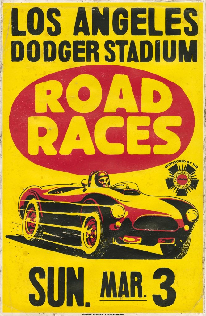


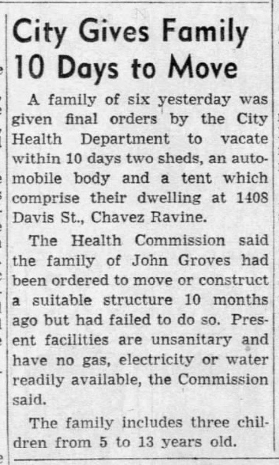
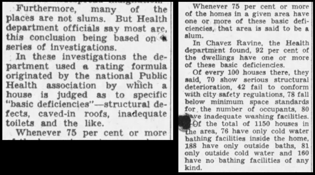
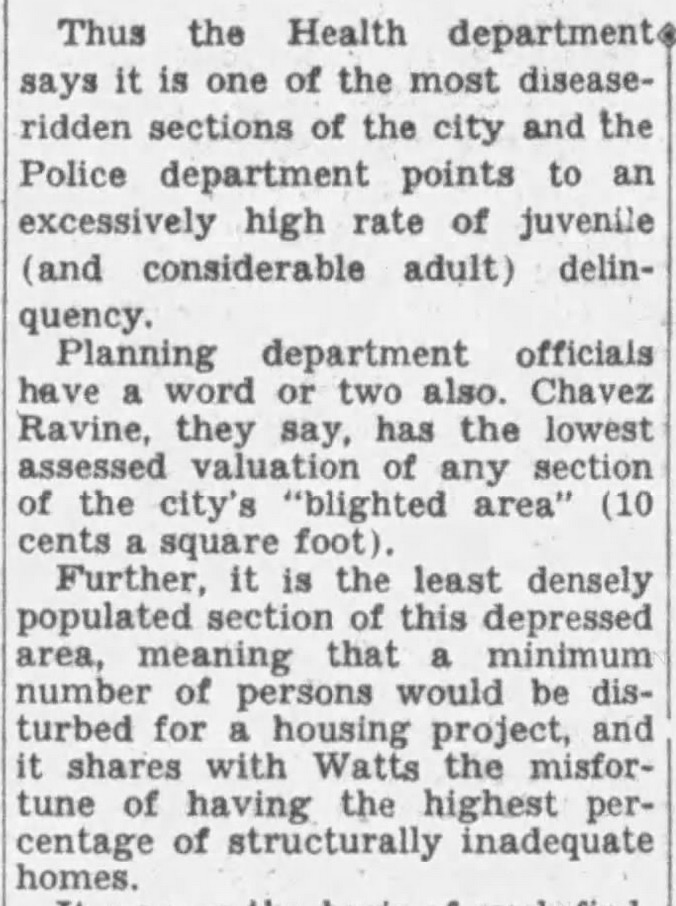
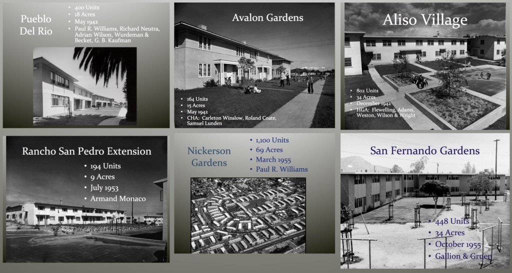
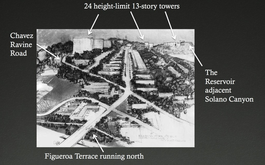


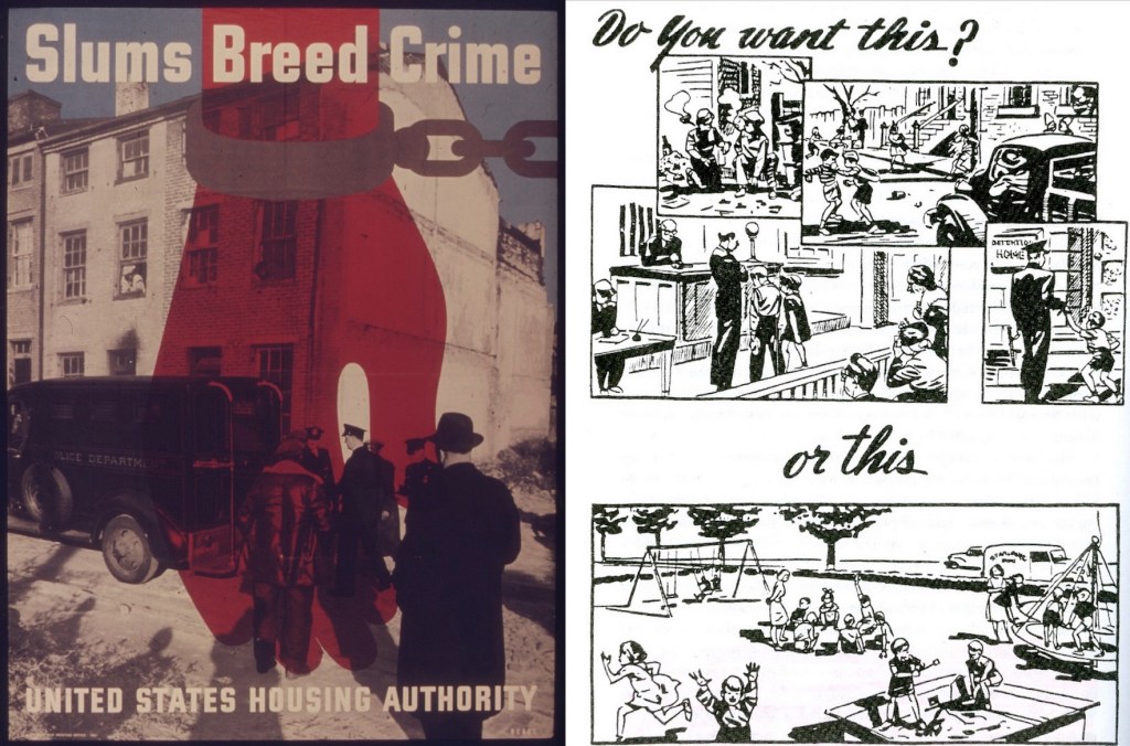
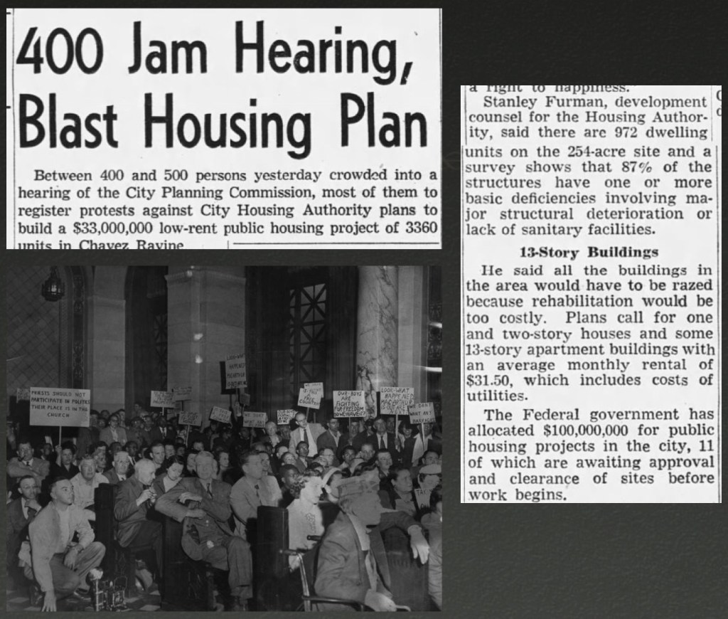
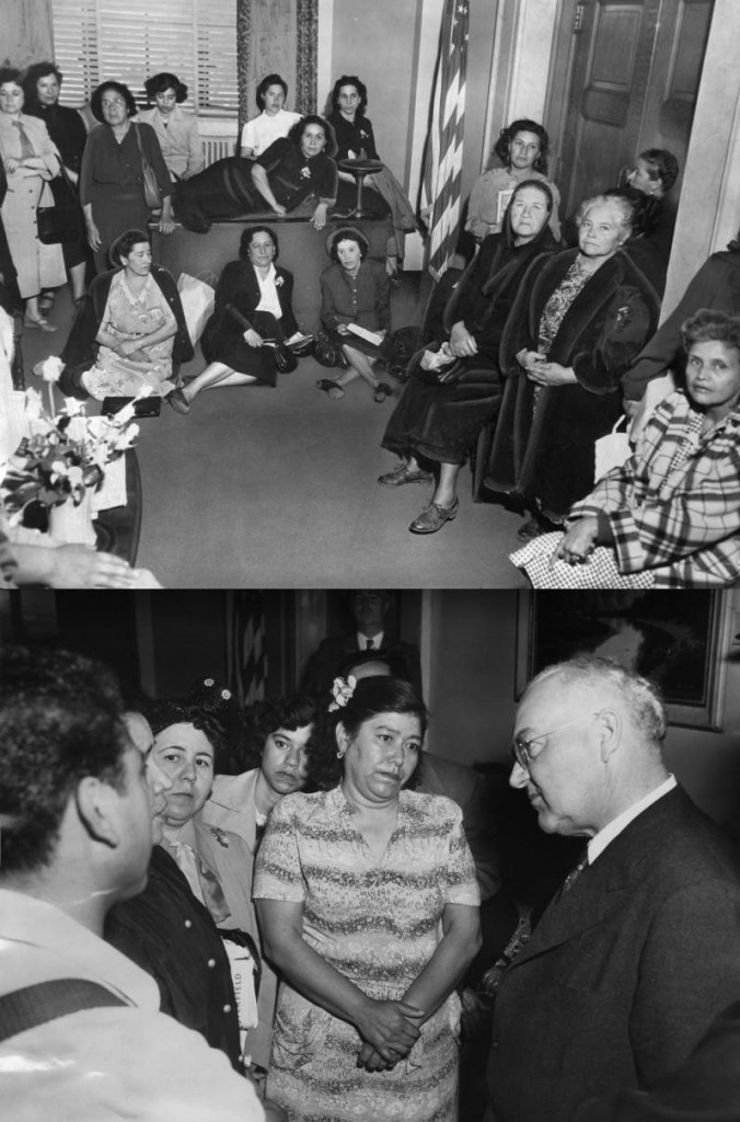


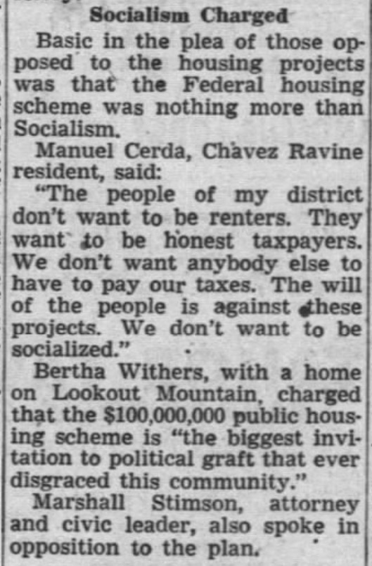


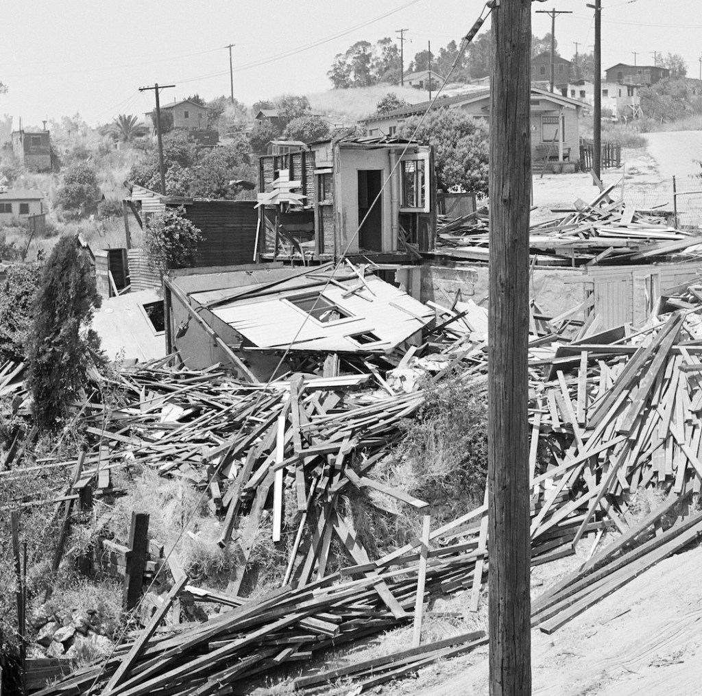
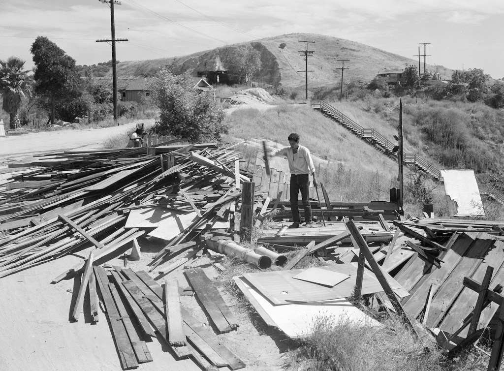


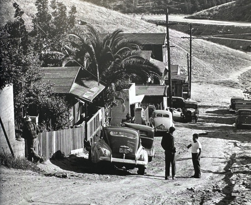


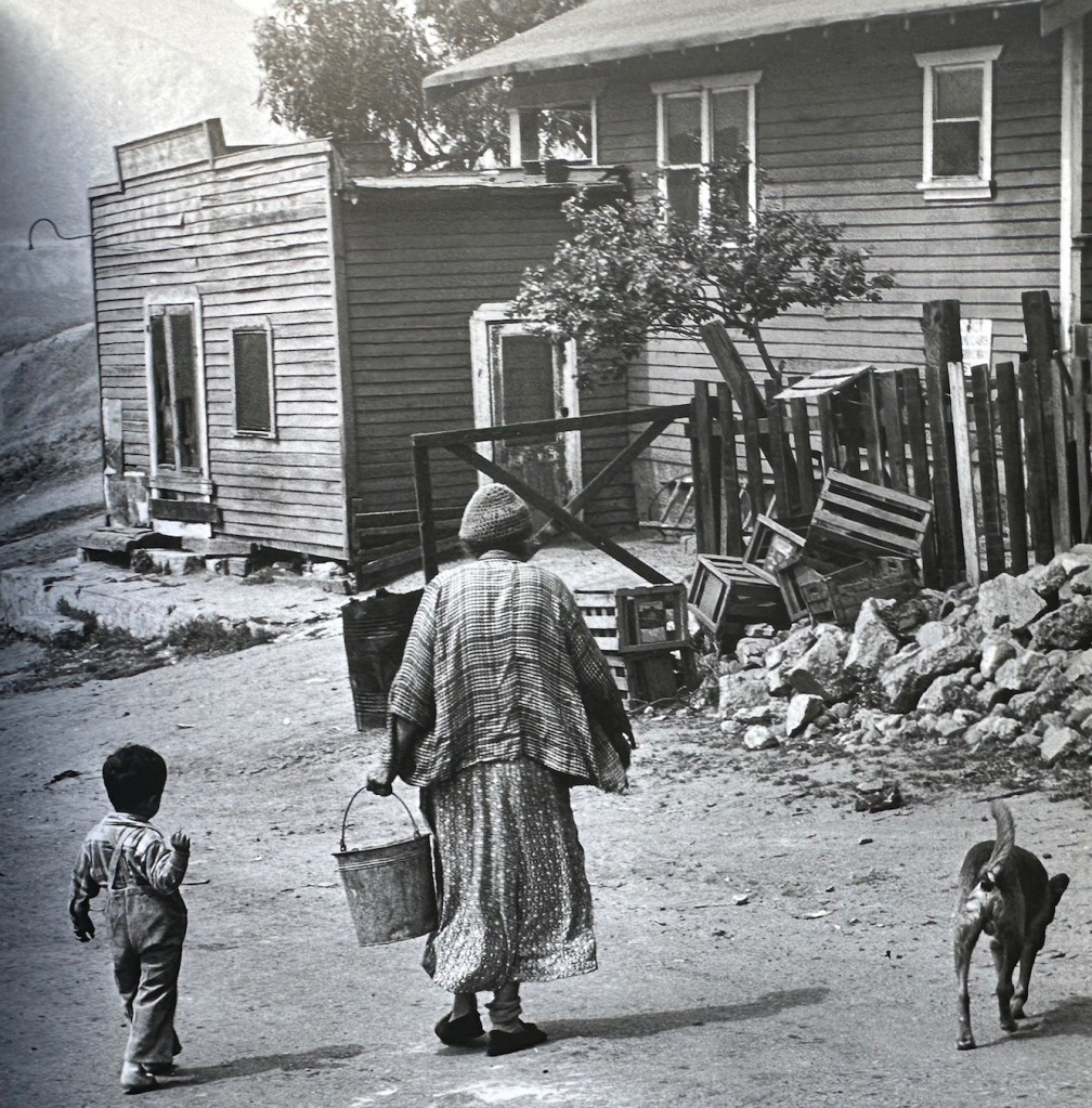


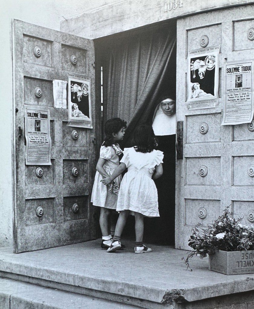


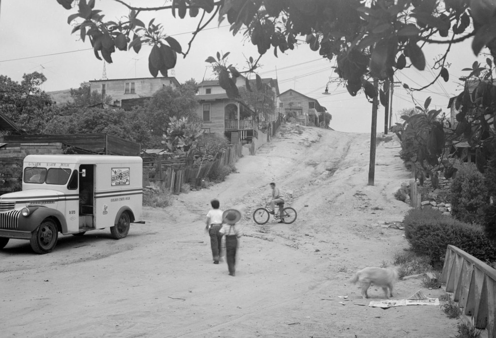


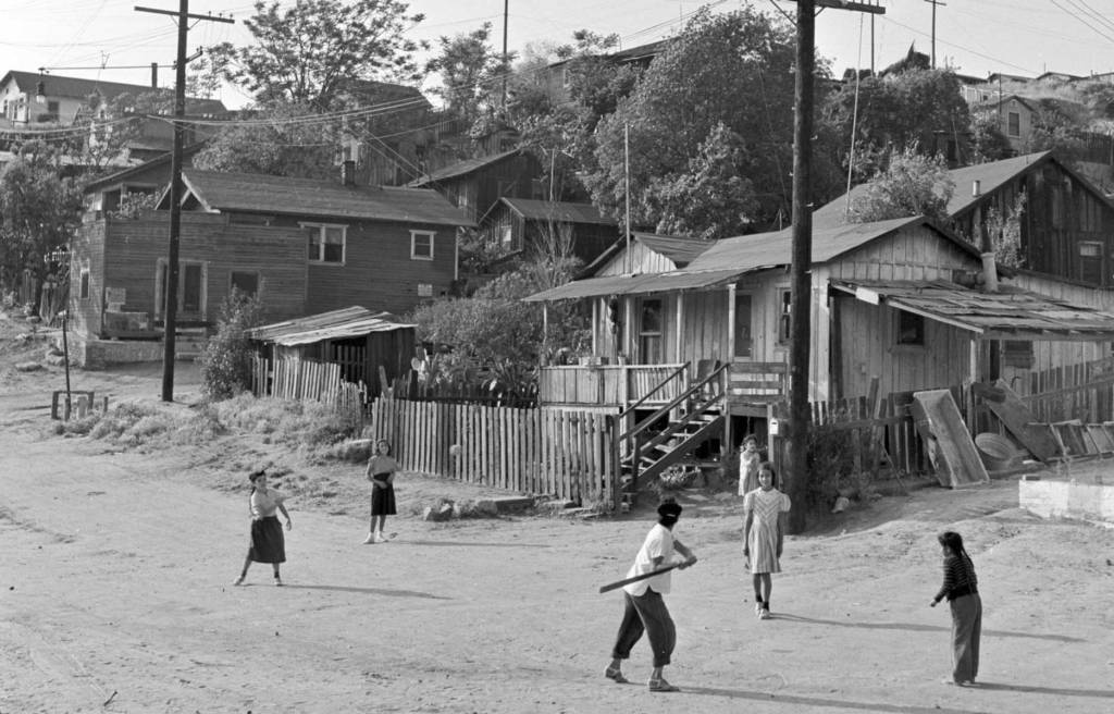


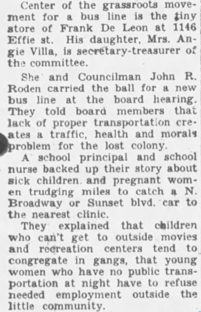

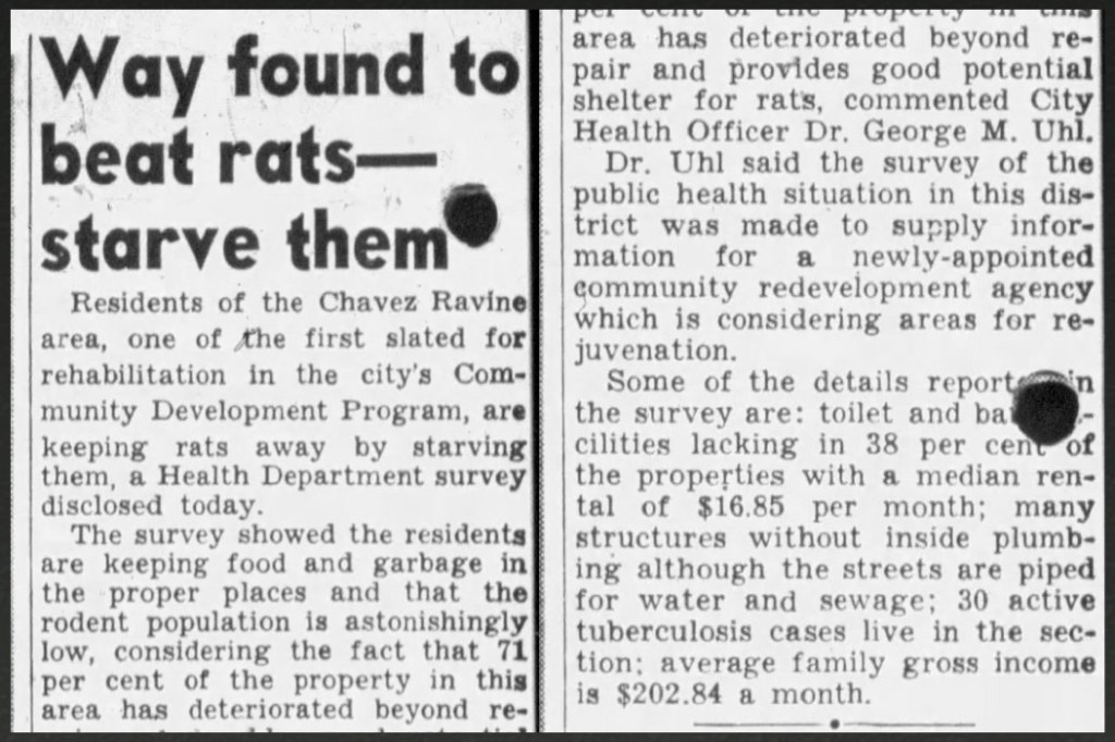
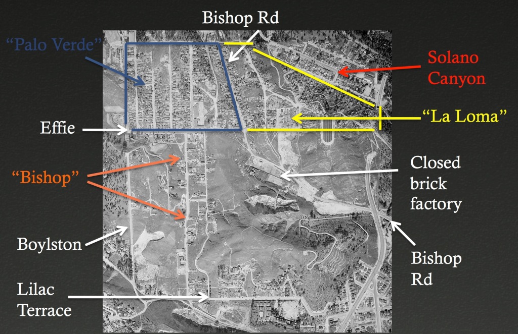
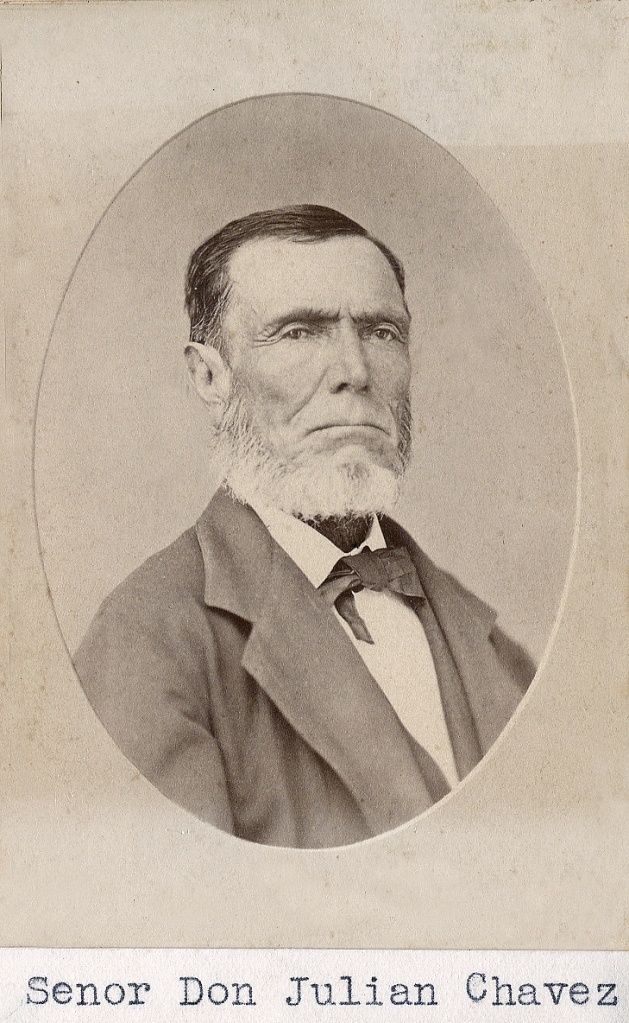
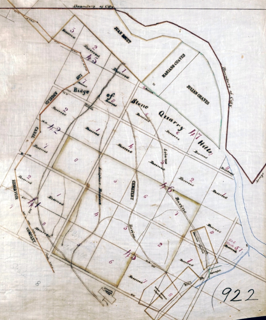
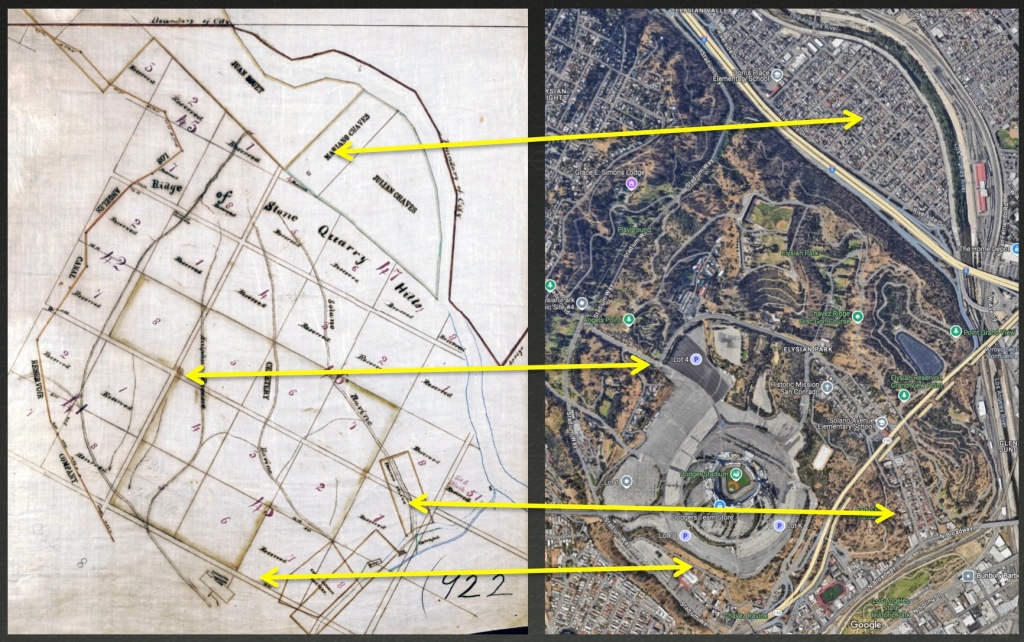
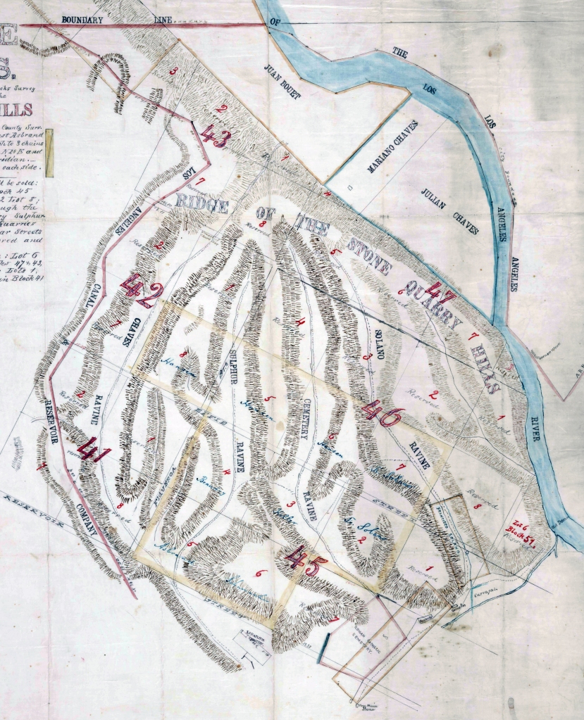
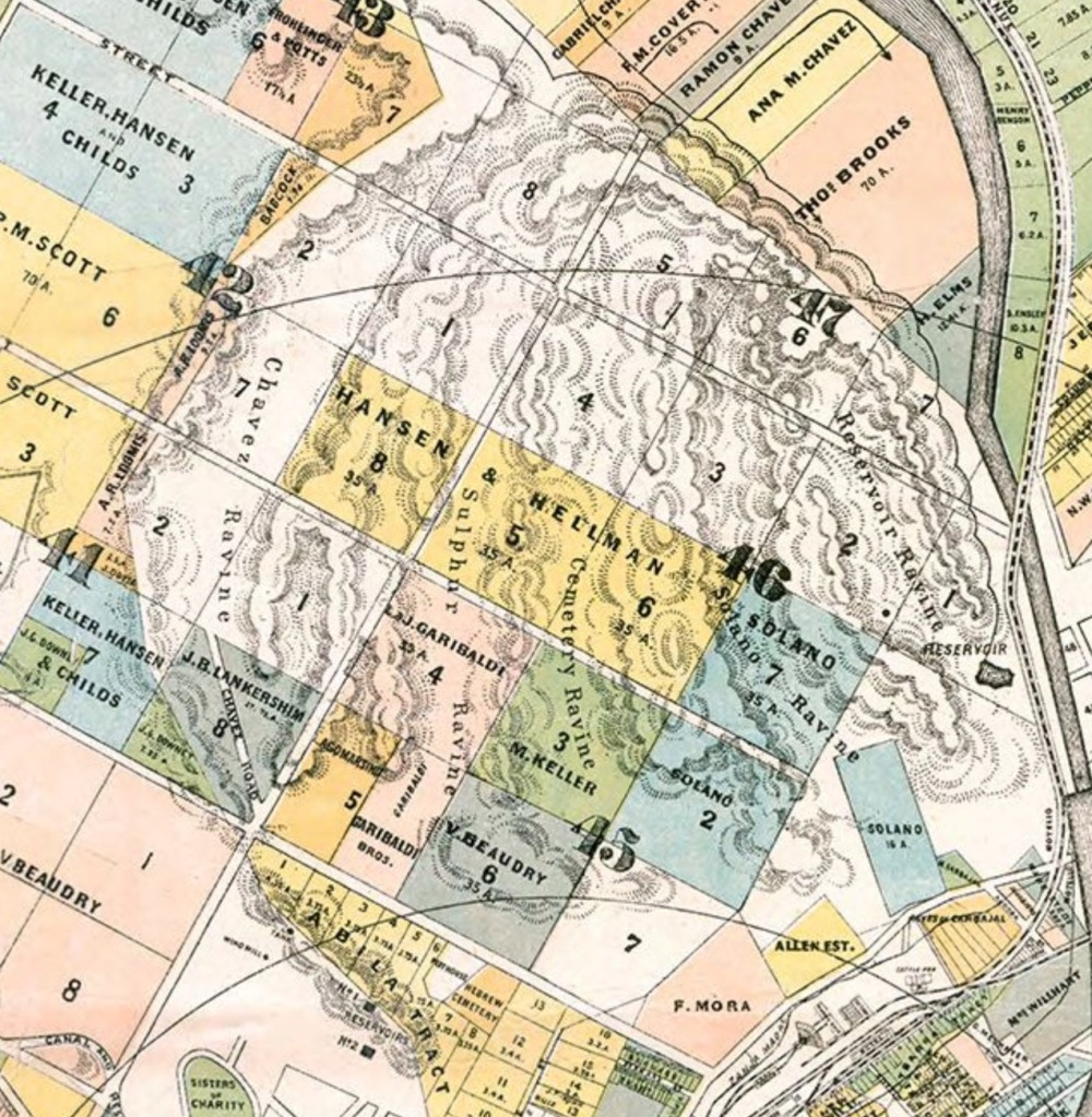
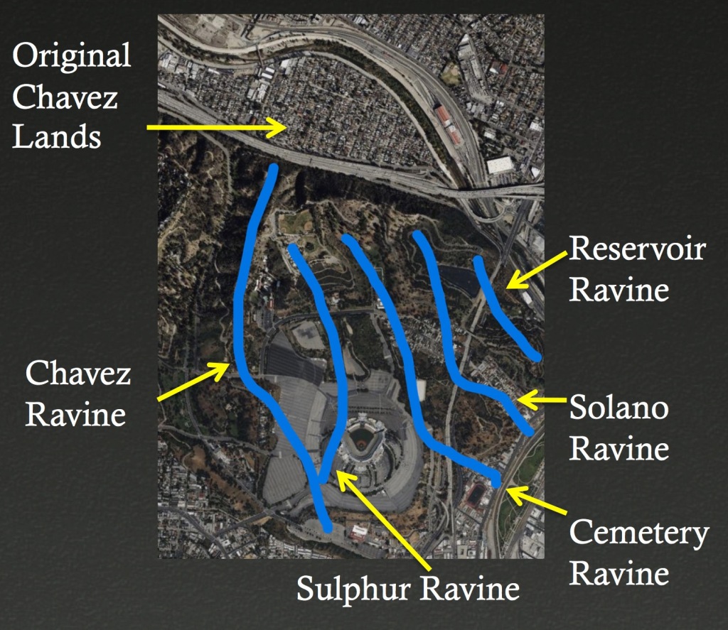

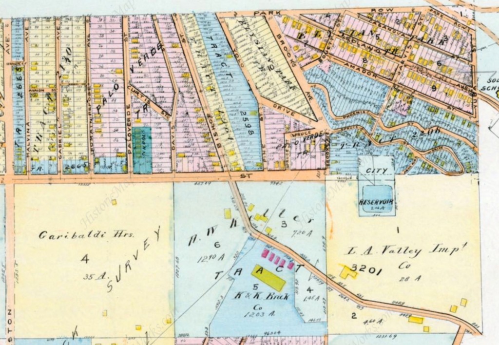
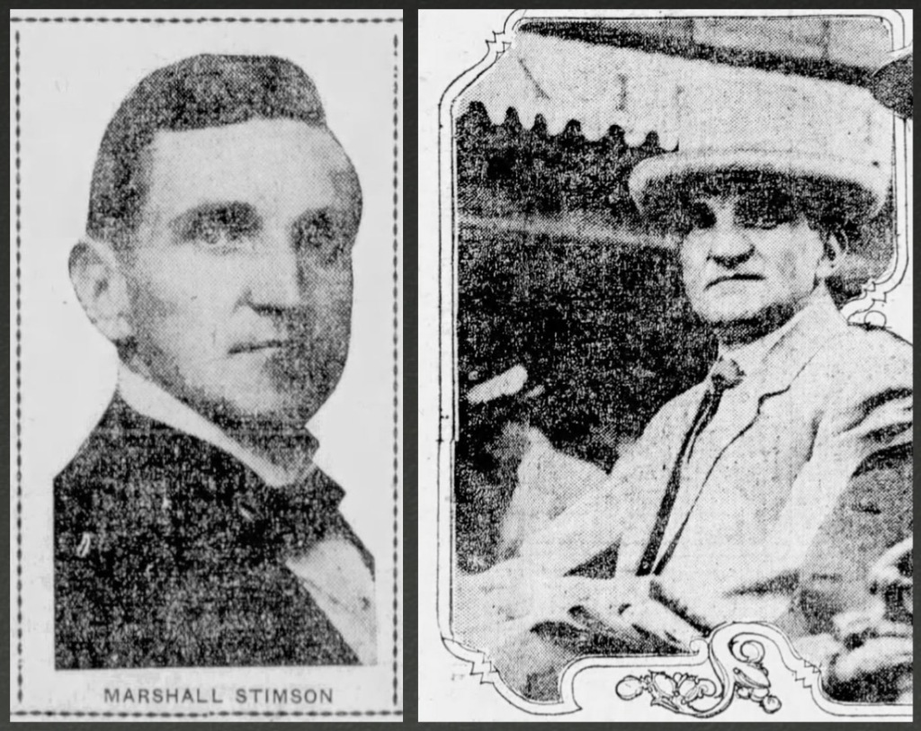
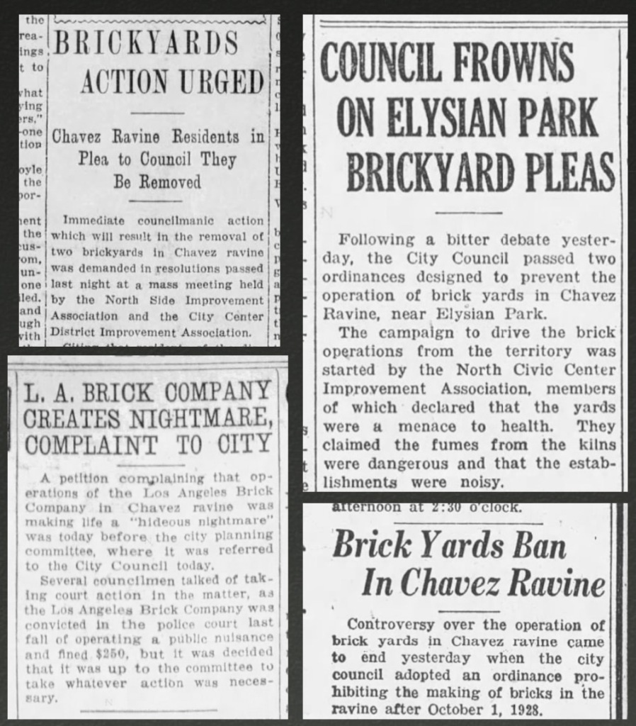
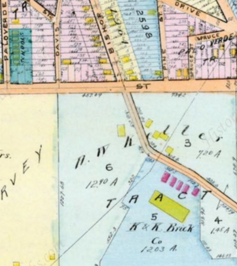
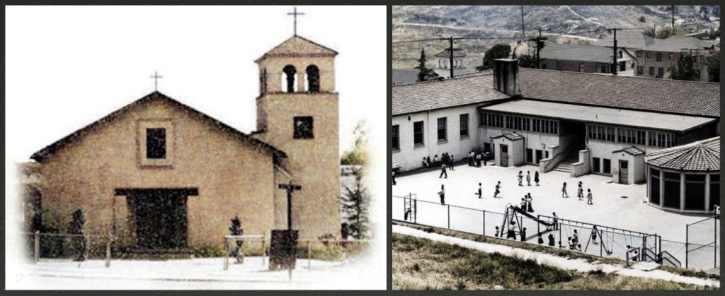
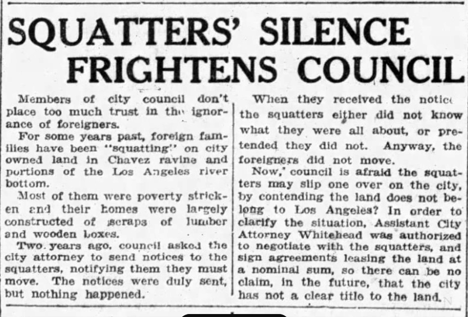
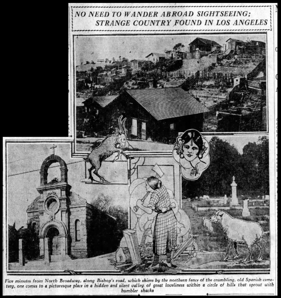


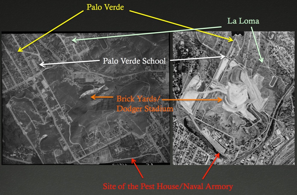
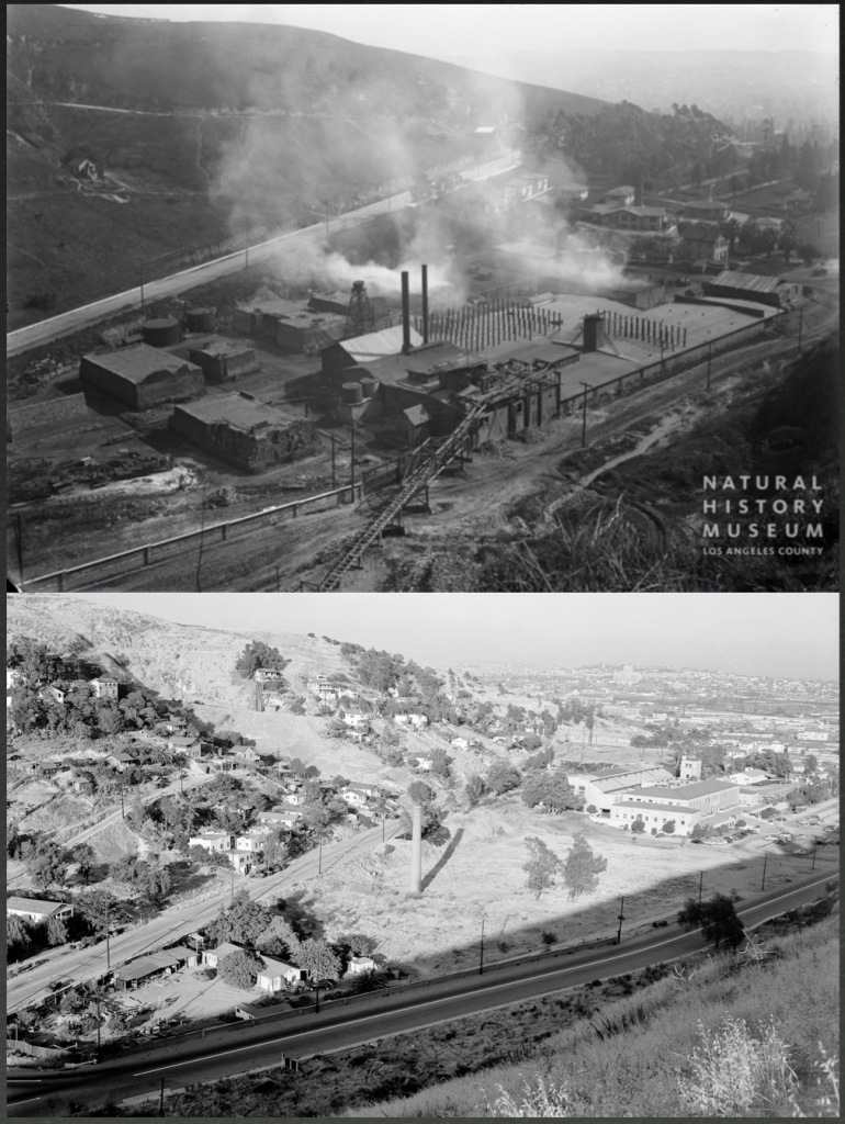


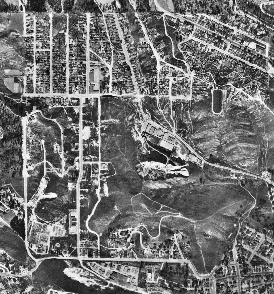

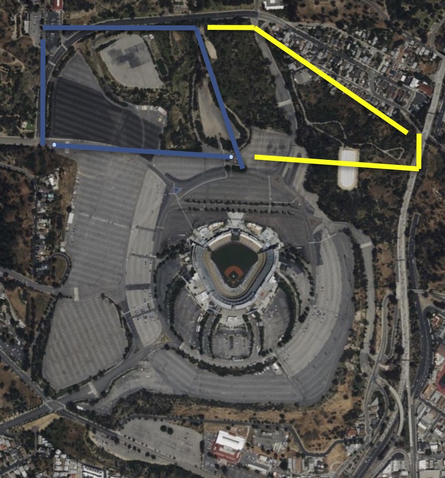
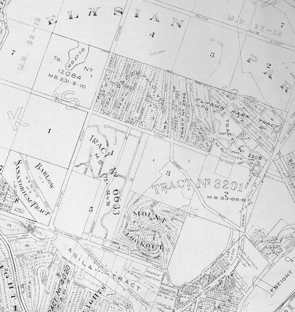
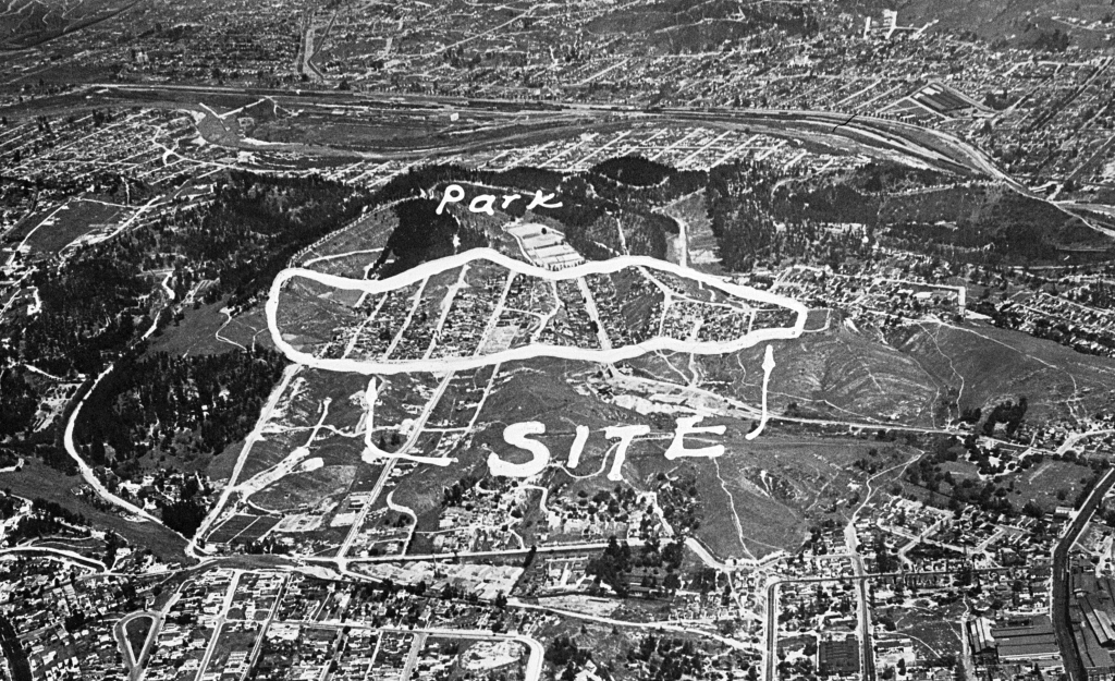
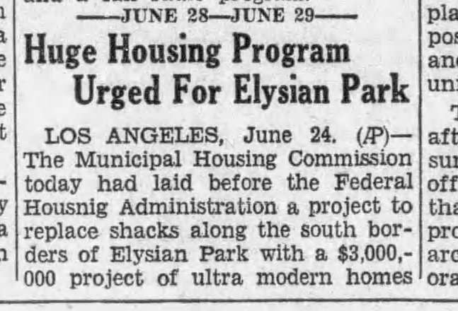
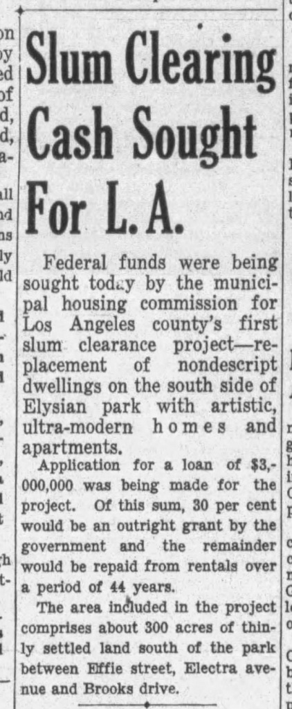
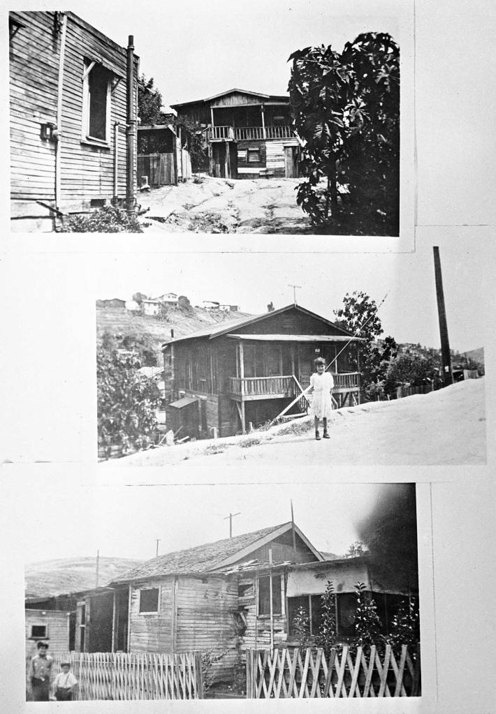

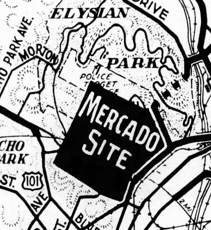
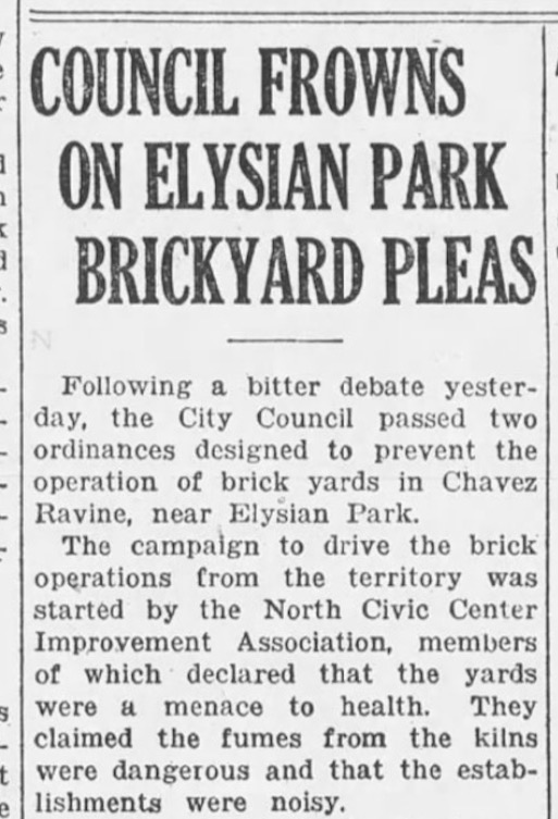
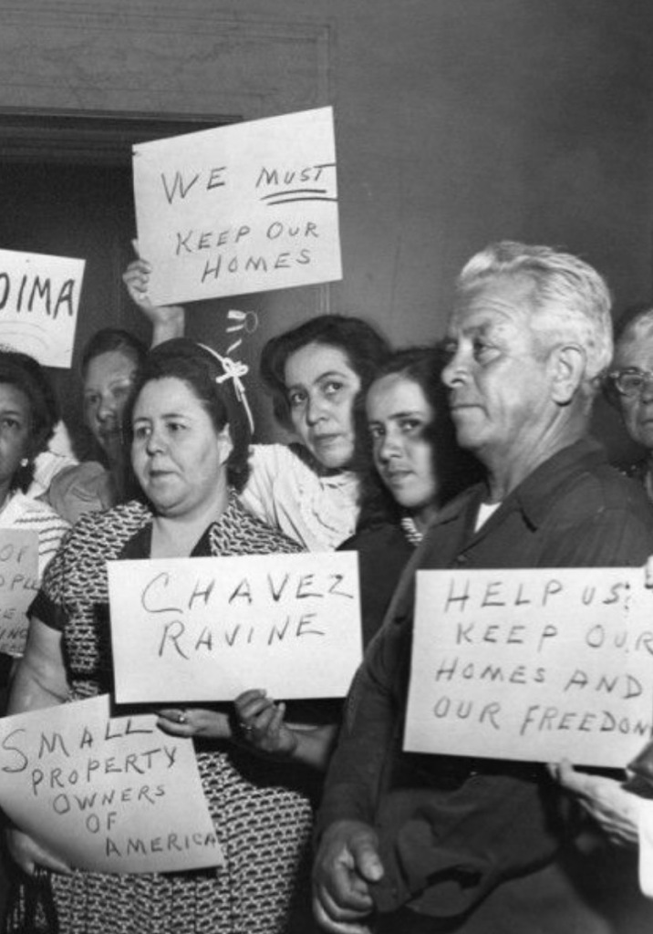

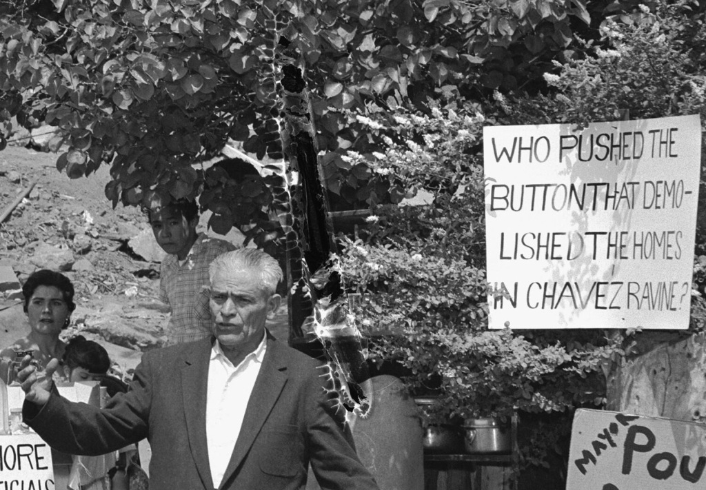
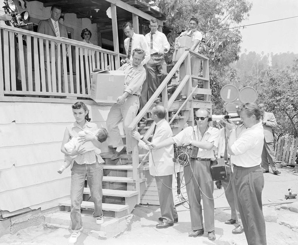

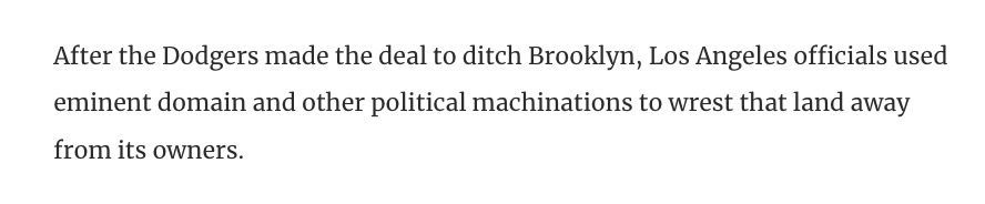

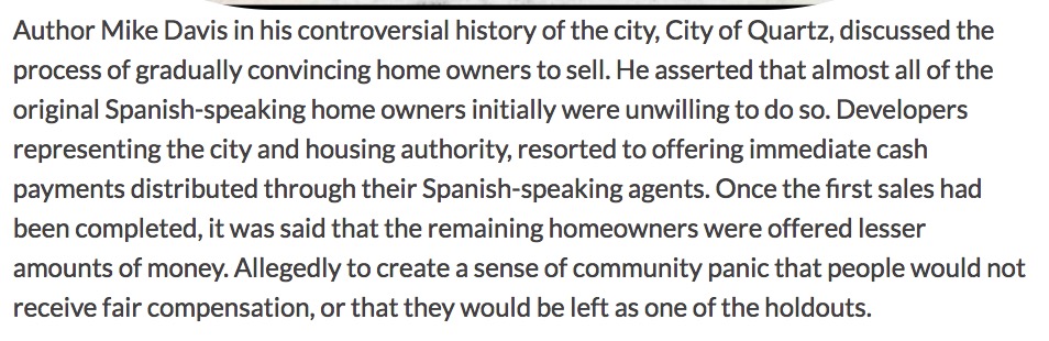
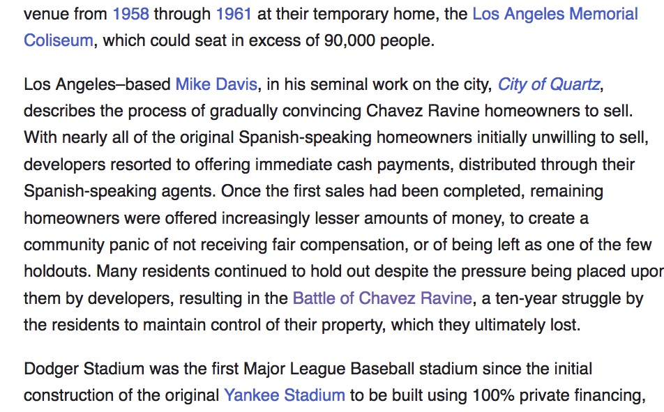
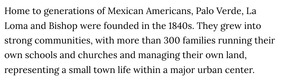
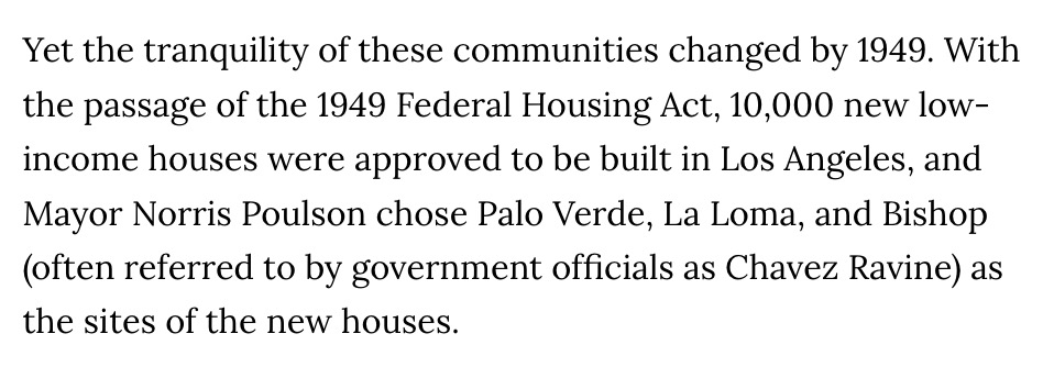


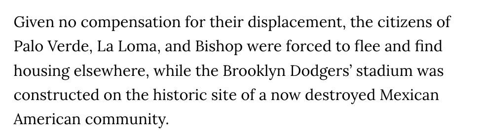


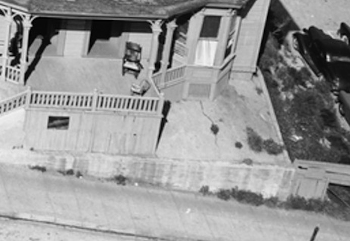


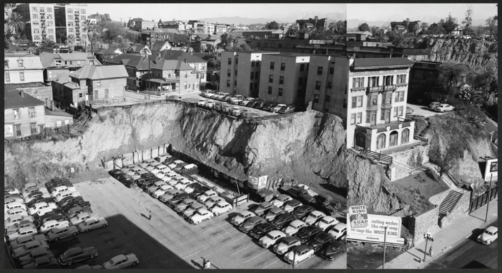
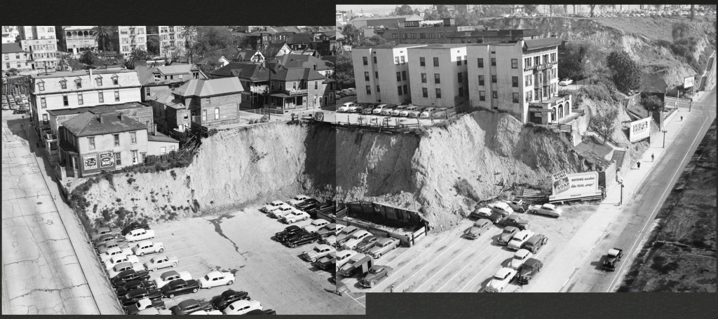


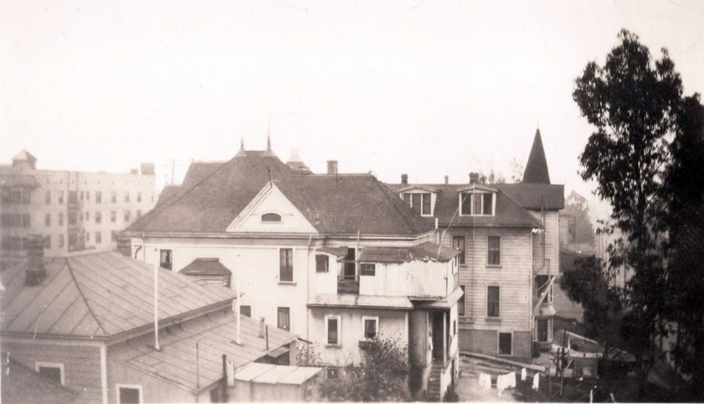
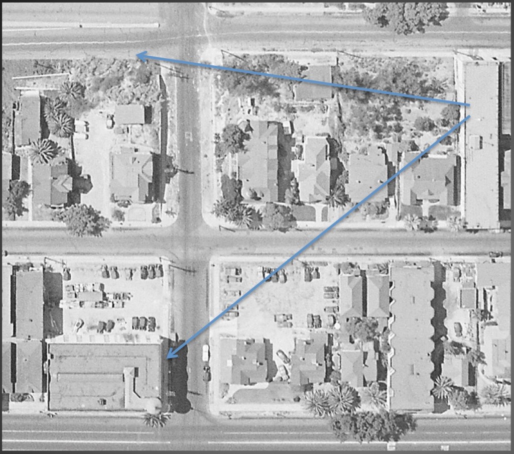


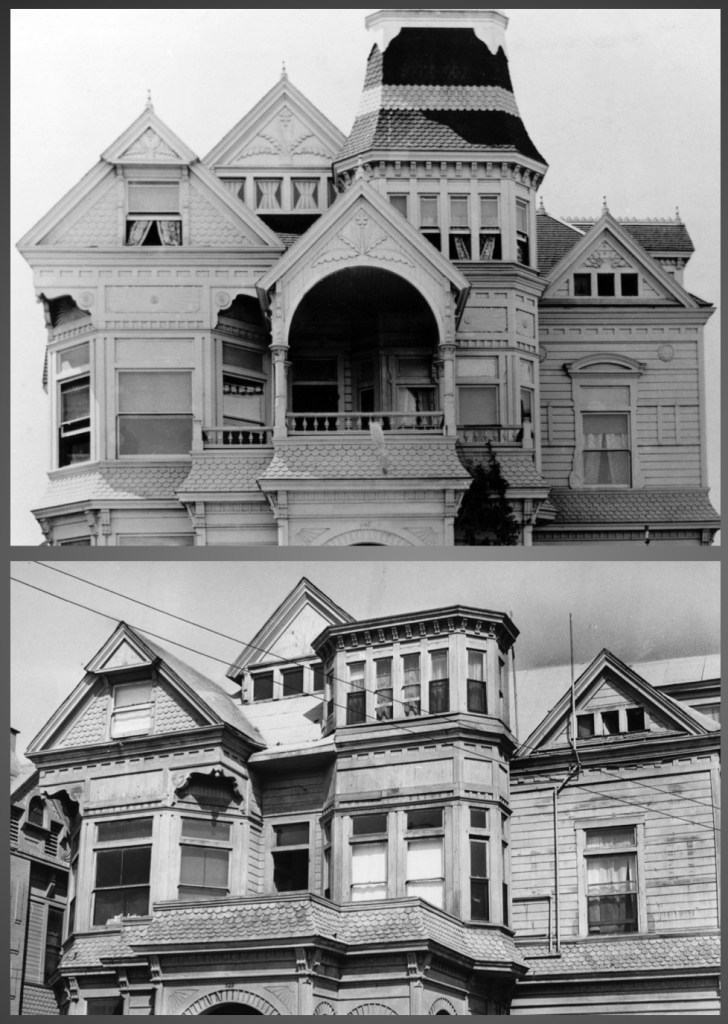


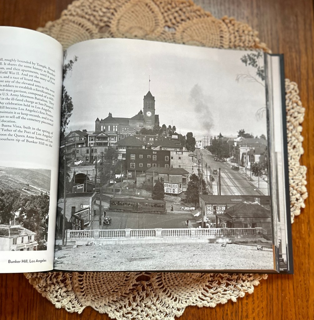


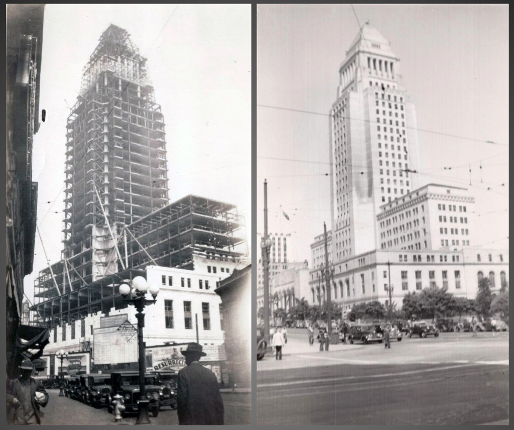

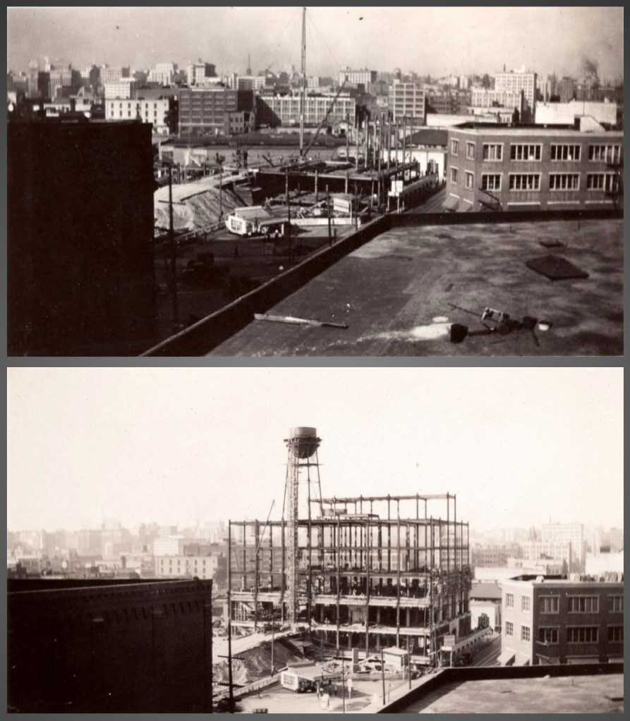


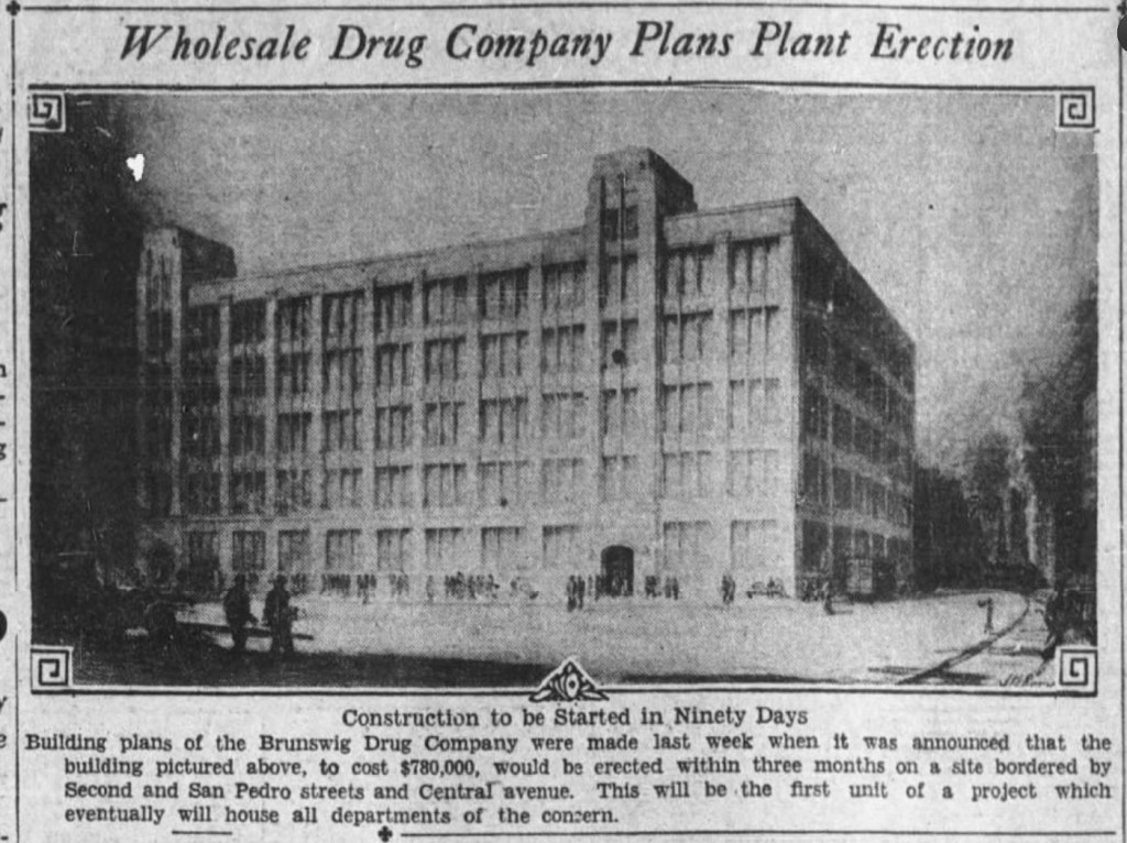


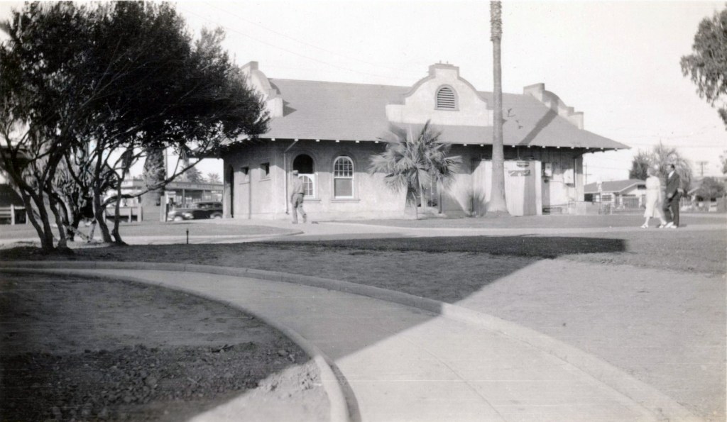

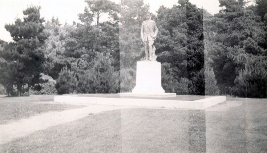
